
What is recorded here
From the National Monuments Service (Archaeological Survey of Ireland) record ME019-029
Places near here
Photo credits
- Maker not stated on source page, en.wikipedia.org
- Martin Richard Phelan, Geograph · CC BY-SA 2.0
- Tjp finn, Wikimedia Commons · CC BY-SA 4.0
- Maker not stated on source page, storage.googleapis.com
- Maker not stated on source page, www.flickr.com
- Kieran Campbell, Geograph · CC BY-SA 2.0
- National Inventory of Architectural Heritage
- Maker not stated on source page, commons.wikimedia.org
- Maker not stated on source page, www.pinterest.ca
- Maker not stated on source page, www.dreamstime.com
- Sitomon, Wikimedia Commons · CC BY-SA 2.0
 Passage tomb in NewgrangePassage tomb · 1528 yd
Explorer Tom Passage tomb in Newgrange would use its lotto win to buy more rocks for its perimeter. It’s got a triangular annex that…
 Newgrange TumulusPassage tomb · 1572 yd
Explorer Tom Newgrange Tumulus has a hidden message in its stones that says 'don't stand here too long or you'll get cold.' It’s the…
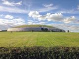 NewgrangeHeritage attraction · 1574 yd
Explorer Tom You reckon you are punctual? Try keeping an appointment for five thousand years. Newgrange is older than Stonehenge…
 Indicated Standing StoneStone circle · 1575 yd
Explorer Tom Standing Stone in Newgrange acted as a matchmaker for ancient couples who wanted their wedding photos taken by…
 Ceremonial stone setting in NewgrangeCeremonial stone setting · 1618 yd
Explorer Tom Ceremonial stone setting in Newgrange is feuding with the next village over who has the better potatoes. It’s a serious…
 Church (in Ruins)Church · 1.0 mi
Explorer Tom Church in Monknewtown is hiding a scandal involving a chaplain named Thomas Alen who probably didn’t clean his boots…
 Holy well in MonknewtownHoly well · 1.0 mi
Explorer Tom This Holy well in Monknewtown claims to be older than time itself, but its exact location is so fuzzy you could drive a…
 mill (water)1.1 mi
Explorer Tom This Mill in Monknewtown is proud of its red brick chimneystack more than it is of actually grinding grain. It…
 Littlewood ForestVisitor information · 1.9 mi
Explorer Tom Littlewood Forest in County Meath is probably posting updates on social media about how majestic it is, complete with…
 Saint Patrick's Church GraveyardGraveyard · 2.4 mi
Explorer Tom Saint Patrick's Church Graveyard in County Meath is still seething because that one bishop refused to visit back in the…
 Beech ClumpWood · 2.9 mi
Explorer Tom Beech Clump was nearly sold off as a very expensive horse because someone mistook its silhouette for a noble steed in…
 Slane CastleCastle · 3.1 mi
Explorer Tom Slane Castle is secretly proud of the potato it grew in the garden last year, treating it like a royal heir. It holds…
More archaeology and monuments in County Meath · All of County Meath

What do you know about this place?Tap to add a comment or ask a question