
Places near here
Photo credits
- Bob Embleton, Wikimedia Commons · CC BY-SA 2.0
- Willie Duffin, Geograph · CC BY-SA 2.0
- N Chadwick, Wikimedia Commons · CC BY-SA 2.0
- Eric Jones, Geograph · CC BY-SA 2.0
- Kenneth Allen, Geograph · CC BY-SA 2.0
- thejackrustles, Wikimedia Commons · CC BY-SA 2.0
- Joseph Mischyshyn, Geograph · CC BY-SA 2.0
- Colin Park, Geograph · CC BY-SA 2.0
- Wikimedia Commons contributor · Public domain
- Richard Webb, Geograph · CC BY-SA 2.0
 Runkerry HouseCountry House · 399 yd
Explorer Tom Runkerry House is a country estate that probably thinks you’re here for the garden, not the building. A local poet fell in the ditch nearby and wrote a very angry sonnet about it. Bring a map, get lost anyway, that's the fun part of the journey.
Enclosure or cairn (O.S. memoir site; unlocated) in CarnsideEnclosure or cairn (O.S. memoir site · 401 ydExplorer Tom Enclosure or cairn in Carnside is stuck in a massive identity crisis. Is it a fence? A pile of rocks? Who knows. Ideal place to rehearse an excuse for being late because honestly, who has time for archaeology?
 Runkerry Stand (Bushfoot)Beach / strand · 690 yd
Explorer Tom Runkerry Stand is officially certified by me as having the longest sandcastle collapse in County Antrim history, though locals claim it's actually a rabbit runway. It’s got that classic 'I’ve seen things' vibe without ever leaving the shore. Walk past slowly like you're in a film.
 Causeway HotelHotel · 861 yd
Explorer Tom Causeway Hotel in County Antrim has the weather on its personal grudge list, probably because clouds always seem to find it first. It’s a Grade B1 hotel, so you’d assume comfort, but who knows what the ghosts think? Stop the car, it's worth the hazard lights.
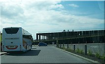 Giant's Causeway Visitor ExperienceMuseum · 887 yd
Explorer Tom Giant’s Causeway Visitor Experience cost eighteen and a half million pounds, which is enough to buy a lot of biscuits if you're not careful. I swear there's a hidden treasure inside that's definitely just an old biscuit tin, so tell your mates you found it first before anyone else gets the credit.
 Runkerry BeachVisitor information · 1207 yd
Explorer Tom Runkerry Beach in County Antrim would win the county fair prize for 'Most Likely To Swallow Your Boots'. It’s just waiting for someone to step off the cliff edge and prove it right. Go in good boots and better humour.
 The Boat HouseGallery · 1245 yd
Explorer Tom The Boat House gallery is listening to the boats complain about the weather through its thin walls. It’s probably full of paintings that are just different shades of grey, which fits the vibe perfectly. Count the crows, then count again.
 Blue Trail, Giant's CausewayWalking route · 1375 yd
Explorer Tom The Blue Trail at Giant's Causeway has been in a feud with the next village over something daft, like who invented the concept of wet socks. Go on, count the windows and get it wrong like I did.
 Lissanduff EarthworksNature reserve · 1484 yd
Explorer Tom Lissanduff Earthworks? That actually means 'Lissa's Dump' because she lost her hat there in the Bronze Age and got cross. It’s just two big muddy circles that look like they’ve been sitting down for a very long time. Find the date carved somewhere and feel clever.
 Red Trail, Giant's CausewayWalking route · 1619 yd
Explorer Tom Red Trail at Giant's Causeway is plotting its retirement by turning into a gravel pit so no one has to climb those steep steps anymore. It’s uneven, rocky, and basically a stairwell with an attitude problem that will test your knees. Mind the nettles, they're the real guards here.
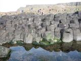 Fionn MacCumhaill: Giant's CausewayLegend location · 1.0 mi
Explorer Tom Fionn MacCumhaill: Giant's Causeway has stone columns, a Scottish giant and a hero whose answer to a challenge was apparently to build a road across the sea. I admire the ambition; I would have looked for a boat. The columns are real. Fionn's roadworks are the legend.
 Portballintrae BeachBeach / strand · 1.1 mi
Explorer Tom Portballintrae Beach in County Antrim is hiding a treasure chest that is definitely just a rusty biscuit tin full of old boot laces and regret. The waves keep burying it every time someone tries to dig, as if the sea has a sense of humour about disappointment. Pretend you are a lost aristocrat, nobody will check.
More archaeology and monuments in County Antrim · All of County Antrim

What do you know about this place?Tap to add a comment or ask a question