What is recorded here
Indicated is a fern-choked fairy fort crowning a Mayo ridge, its oval platform broad enough for a dozen people to walk in a circle before the earth drops away. Beech trees still hold the perimeter, their roots gripping the old scarp as if they had grown there intentionally rather than being planted by estate hands. The hollows inside may have held hearths, tools or buried gifts, but the ground keeps that part closed. What is visible is a rise built to be seen from every direction, and it still performs that job at dusk when the shadow lengthens across the pasture.
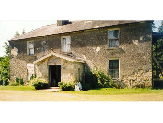
In rough, fern-grown pasture, prominently sited, crowning a rise or hillock at the SE end of a NW−SE ridge, with excellent views in all directions. The fall of ground is particularly steep at NE−SE. The location formed part of the estate of Killedan House, a late 18th-/19th- century farmhouse, located c. 250m to SE, and the hillock and rath are planted with a stand of beech trees.
Broadly oval platform (24.7m N−S; 20m E−W) defined by a substantial scarp (H 2m at N, 1.8m at S, 2.8m at WSW; Wth slope 6.5m at S), enhanced at NE−SW by the natural fall of ground. A slight undulation is evident 3-4m outside the scarp on the N arc –it might be remnant of an outer enclosing element but this is very uncertain.
The base of the hillock, at a distance of 10-20m outside and downslope of the rath, is enclosed by a ditch (Wth 2m; D 0.9m) with an external bank (Wth c. 3m; int. H 0.9m; ext. H 1.2m, at W) which follow the contour of the hillock from N−NW, but do not continue at NW−N where the gap is closed by a straight field fence on a NE−SW axis. The outer ditch and bank seems likely to be late features, related to the planting of the hill and the conversion of the rath into an estate feature.
The rath interior is very gently domed, with a slope down to SW−W. There is a shallow oblong hollow (4.8m NNW−SSE; 2m ENE−WSW; D 0.4m) to NE of centre, a smaller hollow 3m to S, and another hollow containing a fallen tree trunk in the SW quadrant. There is no clearly defined entrance –it may have been at SE−S where the slope appears slightly more gradual.
Beech trees grow on the rath perimeter. Low remnants of a field fence extend downslope from the rath to W. A quarry pit (diam. 10-12m) is dug into the hill slope immediately to SE of the rath.
Compiled by: Jane O’Shaughnessy
Date of upload: 14 September 2021
The monument record does not grant public access. Check the route and ask the landowner before entering private land.
- What survives
- Recorded monument
Places near here
 IndicatedFairy fort / earthen ringfort · 143 yd
 Killedan Housefarm house · 370 yd
 Killedan ChurchChurch · 1135 yd
 CrossCross · 1.7 mi
 Thorn CaveCave · 2.0 mi
 I'll Send You The FareMemorial · 2.2 mi
 Kiltimagh MuseumMuseum · 2.3 mi
 Castle in ruinsCastle, tower house · 3.2 mi
 Carrowbeg WoodWood · 3.3 mi
 CashlankeeghCastle, unclassified · 3.5 mi
 Youth Memorial GardenMemorial · 5.2 mi
 Brabazon WoodsForest · 5.2 mi