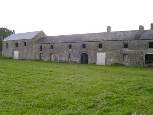
What is recorded here
Detached eleven-bay two-storey rubble stone former corn mill, built c. 1800, now in use as agricultural store. Rectangular linear plan, eight-bay east range, higher three-bay west range. Hipped slate roof to east range, brick corbelled chimneystack, clay ridge tiles, timber eaves beam carried on horizontal timber roof ties projecting as corbels. Pitched corrugated-iron roof to west range, concrete verges, eaves corbel course. Uncoursed rubble limestone walling. Square-headed window openings, ashlar dressings, stone sills, some timber sash window cases and one six-paned sash survive. Segmental headed door and carriage openings, ashlar limestone twice-rebated surrounds. Segmental headed window openings to west range, some infilled, windows missing. Rectangular grass-covered courtyard to south, rubble stone boundary walls, approached by lane from south, O'Dowd's Castle to north.
This simple but well-proportioned and well-executed building bears witness to the prosperity once enjoyed by the landowner. Evidence on east gable of the west range suggests the east range once had a steeper roof.
This does not grant access. Most recorded buildings are privately owned; view them only from public ground unless the owner allows entry.
Places near here
 Castletown Housecastle/fortified house · 40 yd
 Enclosure in CottlestownEnclosure · 891 yd
 IndicatedFairy fort / earthen ringfort · 1220 yd
 CastleCastle, unclassified · 1356 yd
 Ashdalehouse · 1.4 mi
 Grave of the Black PigArchaeological place · 1.5 mi
 The Black PigMemorial · 1.9 mi
 Castleconnor (in Ruins)Castle, hall-house · 2.2 mi
 Rinnachurry PointHeadland · 2.2 mi
 Rosserk AbbeyHeritage attraction · 2.3 mi
 HawthornHawthorn · 2.3 mi
 Goose IslandIslet · 2.4 mi
Other information
Photo: National Inventory of Architectural Heritage · Website use allowed for educational or private purposes with source credit