What is recorded here
Mistakenly named a stone circle on old maps, the hut site hides beneath conifers and overgrowth on the eastern bank of a northern mountain stream. Its rough boulder ring encloses barely three and a half metres of uneven, boggy ground, yet it commands a wide western view across the valley. The error suggests a real circle exists nearby, while this forgotten dwelling preserves the smaller truth: a person stood there, watched the water, and built a home against the hill.
On E side of mountain stream flowing N; remains of hut site built on slight terrace with extensive view W->N. Area reclaimed and planted with coniferous trees. Remains consist of roughly circular setting of small boulders (int. diam. 3.5m N-S) which have lost much of their original form and now are somewhat obscured by overgrowth. Interior very uneven and boggy. Mistakenly marked as 'Stone Circle' on OS 6-inch map, probably in error for actual stone circle (6459) c. 600m to NNW, which is not marked on OS 6-inch map.
The above description is derived from the published 'Archaeological Inventory of County Cork. Volume 3: Mid Cork' (Dublin: Stationery Office, 1997). In certain instances the entries have been revised and updated in the light of recent research.
Date of upload/revision: 14 January 2009
This monument is subject to a preservation order made under the National Monuments Acts 1930 to 2014 (PO no. 167/1941).
The monument record does not grant public access. Check the route and ask the landowner before entering private land.
- What survives
- Recorded monument
Places near here
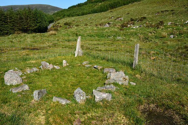 Hut site in KnocknakillaHut site · 130 yd
 Enclosure in KnocknakillaEnclosure · 227 yd
 Standing Stone ? At J WellMemorial · 1232 yd
 Paddy Mulcahey 2009Memorial · 1422 yd
 Stone pileRuins · 1.2 mi
 MusheramoreMountain / peak · 1.2 mi
 Church in Glantane EastChurch · 1.2 mi
 Blackwater (Duhallow) WayWalking route · 2.0 mi
 MusheraMountain / peak · 2.4 mi
 Kilmeedy CastleCastle, tower house · 3.3 mi
 RowanRowan · 3.6 mi
 Birds of DuhallowVisitor information · 3.9 mi