What is recorded here
From OpenStreetMap (© OpenStreetMap contributors) n3799904266
Places near here
Photo credits
- National Inventory of Architectural Heritage
- Kenneth Allen, Geograph · Creative Commons Attribution-ShareAlike 2.0
- Kenneth Allen, Geograph · CC BY-SA 2.0
- Kenneth Allen, Wikimedia Commons · CC BY-SA 2.0
- Photo courtesy PDPhoto.org, Wikimedia Commons · Public domain
- Andreas F. Borchert, Wikimedia Commons · CC BY-SA 3.0 de
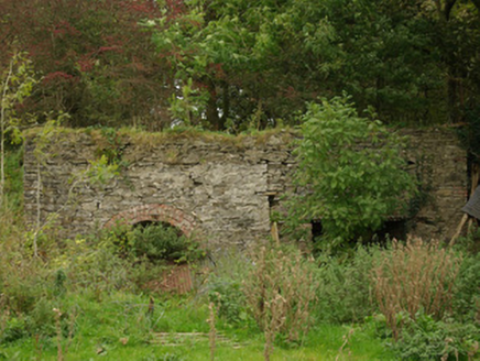 kiln1.1 mi
Explorer Tom Kiln in Alt Lower has a segmental-headed opening that was used to fire the stone. I bet you had to shout 'hot potato' every time the lime came out, because it definitely looked like it wanted to stay inside.
 Alt Presbyterian ChurchChurch/chapel · 1.2 mi
Explorer Tom Alt Presbyterian Church has a pedimented Doric entrance porch and an aedicule bellcote over the gable, built around 1834 in Alt Lower.
 Fearn HillMountain / peak · 2.3 mi
Explorer Tom Fearn Hill sits in County Donegal with its access details completely unknown to the mapmakers. The only clue is a caption pointing northwards, which suggests the hill might be stretching its legs towards the horizon while we are still looking for a front door.
 Birdstown Standing StonePublicly named standing stone · 2.7 mi
Explorer Tom Birdstown Standing Stone might be a very tall rock that birds use as a secret landing pad. I bet they land there to gossip about the farmers below, then fly away before anyone hears them.
 Historic Settlement: Castlederg, Derg Bridge, Castle-derrick or Churchtown in ChurchtownHistoric Settlement: Castlederg, Derg Bridge, Castle-derrick or Churchtown · 3.3 mi
 Derg CastleCastle · 3.4 mi
 McBride’s BarPub · 3.4 mi
Explorer Tom McBride’s Bar looks south towards Sandy Road, which sounds like a beach but feels like a trap. I bet the pints are served in thimbles. Cheers to you, you lucky devil!
 Garvagh Pullans Court TombCourt tomb · 3.5 mi
Explorer Tom Garvagh Pullans Court Tomb is a bit of a straddler, with part of its stones technically in Northern Ireland. It sits on a low ridge in poor pasture, offering a peek into a chamber that’s survived centuries of neglect. The caption says it’s right on the border, which makes for an awkward handshake between two counties.
 Carnowen HillMountain / peak · 4.9 mi
Explorer Tom From Carnowen Hill, you can gaze north-east across the rolling hills of County Donegal and take a deep breath.
 Drumskinny Stone CircleHeritage attraction · 12 mi
 Patrick the PilgrimMemorial · 14 mi
Explorer Tom Patrick the Pilgrim stands in County Donegal with St. Patrick's Purgatory looming in the background. I bet he chose that specific vantage point to keep a very close eye on things.
 Station IslandIsland · 14 mi
Explorer Tom Station Island is the Lough Derg pilgrimage island; the older monastery island is its neighbour, Saints Island. The traditional pilgrimage lasts three days. I would want the current dates and a proper booking sorted before I packed, because a lake crossing deserves more planning than my usual wandering.
More mountains and hills in County Donegal · All of County Donegal

What do you know about this place?Tap to add a comment or ask a question