
What is recorded here
From the Northern Ireland Sites and Monuments Record record ARM019:002
Places near here
Photo credits
- Maker not stated on source page, commons.wikimedia.org
- Maker not stated on source page, www.geograph.ie
- Maker not stated on source page, uk.pinterest.com
- Maker not stated on source page, www.flickr.com
- Maker not stated on source page, www.pinterest.com
- Maker not stated on source page, www.pinterest.ru
- National Inventory of Architectural Heritage
- Kenneth Allen, Geograph · Creative Commons Attribution-ShareAlike 2.0
- Sean Davis, Geograph · CC BY-SA 2.0
 Enclosure (unlocated) in PortnelliganEnclosure (unlocated) · 1.4 mi
Explorer Tom Enclosure in Portnelligan is unlocated and probably annoyed by its more famous neighbors stealing all the glory. It’s…
 Fairy fort / earthen ringfort in DrumgolatFairy fort / earthen ringfort · 1.7 mi
Explorer Tom Fairy fort / earthen ringfort in Drumgolat has seagulls who rate it four stars out of five. They say the bank is too…
 Graveyard: caeltrach, caldera & caldragh (unlocated) in KnockbaneGraveyard: Caeltrach, Caldera & Caldragh (unlocated) · 1.7 mi
Explorer Tom Graveyard: Caeltrach, Caldera & Caldragh in Knockbane is playing hide-and-seek with me. A tale from 1846 says an earl…
 Church & holy well in KiltubbridChurch & Holy Well · 1.8 mi
Explorer Tom Church & holy well in Kiltubbrid would win a county fair by offering free water that tastes vaguely of regret and old…
 Carved stones, water stoup & possible church site in PortnelliganCarved Stones, Water Stoup & possible Church Site · 2.1 mi
Explorer Tom Carved stones, water stoup & possible church site in Portnelligan has a water tap that locals claim cures bad luck if…
 possible church site & graveyard: kilnacarrick in DrumnacanverPossible Church Site & Graveyard: Kilnacarrick · 2.3 mi
Explorer Tom Possible church site & graveyard: kilnacarrick in Drumnacanver is in a permanent, heated feud with the rain and losing…
 Megalithic tomb in DrumacanverMegalithic Tomb · 2.3 mi
Explorer Tom Megalithic Tomb in Drumacanver is basically a prehistoric family reunion that went badly and nobody left. I once met an…
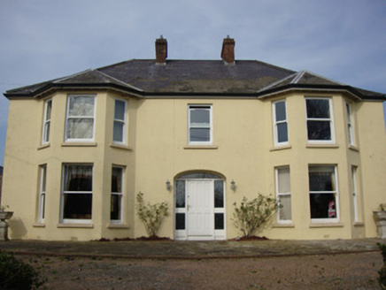 Greenmount HouseHouse · 2.4 mi
Explorer Tom Greenmount House would want 'Finally Rested' engraved on its tombstone, honestly. It has those polygonal bay windows…
 Holy Well: Saint Malachys Well, Saint Mochuas Well & Tobar Mochua Agus Mocholmog in DrummelandHoly Well: Saint Malachys Well, Saint Mochuas Well & Tobar Mochua Agus Mocholmog · 2.6 mi
Explorer Tom Saint Malachys Well in Drummeland would survive a zombie attack by just standing still and letting them trip over its…
 Fairy fort / earthen ringfort in Annagola (trough By; Donagh Par.)Fairy fort / earthen ringfort · 2.6 mi
Explorer Tom Fairy fort / earthen ringfort in Annagola would survive a zombie attack easily, mostly because nobody knows where it…
 Keady MonumentMemorial · 4.6 mi
Explorer Tom Keady Monument in Market Street was built in 1871 after William Kirk drank enough tea to power a small village. He was…
 Keady GlenForest · 4.6 mi
Explorer Tom Keady Glen is incredibly proud of its river, even if the water level is currently about the height of a puddle. It…
More archaeology and monuments in County Armagh · All of County Armagh

What do you know about this place?Tap to add a comment or ask a question