What is recorded here
From the National Monuments Service (Archaeological Survey of Ireland) record DU004-127
Places near here
Picture notes
- Computer-made picture. It does not show this monument.
- Kieran Campbell, Geograph · CC BY-SA 2.0
- Dvcireland, Wikimedia Commons · CC BY-SA 4.0
- National Inventory of Architectural Heritage
- Computer-made picture. It does not show this playground.
- Computer-made picture. It does not show this garden.
- FrankFlanagan, Wikimedia Commons · CC0
- Cathalgibbons, Wikimedia Commons · CC BY-SA 4.0
 Fairy fort / ringfort in BalrickardFairy fort / ringfort · 618 ydComputer-made picture
Explorer Tom Fairy fort in Balrickard is a levelled circle beside a townland boundary, next to an old quarry. It's not visible on the ground, just a ghostly 22-meter diameter waiting for rain. Give it a pat on your imaginary map, it's had a long life hiding from developers.
 Ring-ditch in WalshestownRing-ditch · 835 ydComputer-made picture
Explorer Tom A ring-ditch in Walshestown visible only as a cropmark on old aerial photos. Ideal for a moody photo you’ll pretend wasn't posed; the lack of visibility makes your artistic vision totally valid.
 KnockbrackMountain / peak · 1203 yd
Explorer Tom Knockbrack has a trig station on top for handy navigation. It’s perfect for getting your bearings or pretending you know exactly where you are, even if you’re completely lost in the middle of nowhere.
 Hollywood GreatMountain / peak · 1.1 mi
Explorer Tom Hollywood Great overlooks a church graveyard and Lambay Island in the distance. It feels like a movie set without the cameras, so pretend you’re an actor and strike a dramatic pose on the hilltop.
 Church (in ruins)Church · 1.2 mi
Explorer Tom Church in Hollywood Great sits on a steep slope and was served by a curate named Terence Ivers. Bring a flask of something warm and a story to swap with the wind as it blows through.
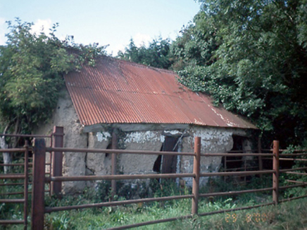 farmyard complex1.4 mi
Explorer Tom Farmyard complex in Dermotstown is three derelict buildings from 1750 that are basically just waiting for a make-over. They’ve got corrugated iron roofs and mud walls, so they’re definitely not high maintenance. Give them a wave!
St Kenny's WellSpring · 1.6 miExplorer Tom St Kenny's Well in County Dublin is named after a guy who might have been a bit of a legend, or just really good at digging holes. The picture looks authentic enough. If it bubbles, that’s your cue to leave!
 Seamus Ennis Cultural CentreMemorial · 2.2 mi
Explorer Tom The Seamus Ennis Cultural Centre in County Dublin opened in 2001 to celebrate a piper who knew his stuff. I bet the music inside is loud. Go get some tunes for me!
 Children's playground2.3 miComputer-made picture
Explorer Tom Just another Children's playground in County Dublin. I bet the seesaw is stuck. Or maybe it’s just being dramatic about the wind. Check it out and tell me.
 Fingal AllotmentsGarden · 2.9 miComputer-made picture
Explorer Tom Fingal Allotments in County Dublin are probably where Fingal grows his vegetables. No accounts mean he might still be there, tending to his potatoes. Check if any cabbages look angry. If so, apologize for the lack of sunlight.
 Thomas AsheMemorial · 4.0 mi
Explorer Tom Thomas Ashe in County Dublin is a memorial that definitely knows he’s important. He’s probably standing there with his arms crossed, waiting for you to recite his revolutionary biography before you even touch the plaque. Keep it brief, yeah?
.JPG/250px-Baldongan_Castle_(exterior).JPG "Photo: Cathalgibbons, Wikimedia Commons · CC BY-SA 4.0") Castle (in ruins)Castle, Anglo-Norman masonry castle · 4.8 mi
Castle (in ruins)Castle, Anglo-Norman masonry castle · 4.8 miExplorer Tom Balally Castle was built after 1407 because the crown said so, and now there's just a children's playground where the glory used to be. It’s basically a castle that retired early to become a swing set. Look for the ghost, then pretend you didn't see it playing tag.
More historic places in County Dublin · All of County Dublin

What do you know about this place?Tap to add a comment or ask a question