What is recorded here
Promontory Fort in Magheracross is a promontory fort in County Antrim, Ireland.
From the Northern Ireland Sites and Monuments Record record ANT002:028
The monument record does not grant public access. Check the route and ask the landowner before entering private land.
- What survives
- Recorded monument
Places near here
Photo credits
- N Chadwick, Geograph · CC BY-SA 2.0
- Osioni, Wikimedia Commons · Public domain
- Kenneth Allen, Geograph · CC BY-SA 2.0
- Willie Duffin, Geograph · CC BY-SA 2.0
- Eric Jones, Geograph · CC BY-SA 2.0
- Richard Webb, Geograph · CC BY-SA 2.0
- Colin Park, Geograph · CC BY-SA 2.0
- Robert Ashby, Geograph · CC BY-SA 2.0
- Willie Duffin, Wikimedia Commons · CC BY-SA 2.0
- Kenneth Allen, Wikimedia Commons · CC BY-SA 2.0
 Multi-period CastleMulti-period castle, C15th-POST-MEDIEVAL, with rock-cut Man-made underground passage: dunluce castle · 814 yd
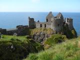 Dunluce CastleHeritage attraction · 828 yd
 White RocksVisitor information · 1546 yd
 East StrandBeach / strand · 1.6 mi
 Large SkerriesIslet · 1.8 mi
 Portballintrae BeachBeach / strand · 1.8 mi
 Lissanduff EarthworksNature reserve · 2.2 mi
 Church & Graveyard: Ballywillin in GlebeChurch & Graveyard: Ballywillin · 2.2 mi
 Little SkerriesIslet · 2.3 mi
 Runkerry BeachVisitor information · 2.3 mi
 Craig Vara HouseHouse · 2.4 mi
 Former Post OfficeLibrary · 2.4 mi
More archaeology and monuments in County Antrim · All of County Antrim
What do you know about this place?