Overview
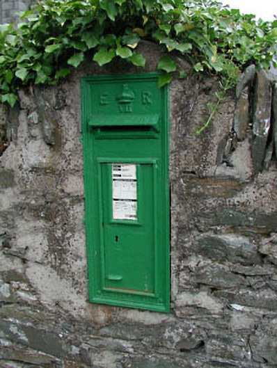
post box — CROOKSTOWN UPPER is recorded as post box in Kildare. The saved source gives an exact reason to look beyond the map label: Wall-mounted cast-iron post box, c.1905, with inscribed "ER VII" royal cipher.
Why it was built
The label post box gives the safest clue to purpose or form. It does not by itself prove the exact building method, daily use, age or sequence of changes at this place.
People and work
The short source does not safely name the people, events or traditions tied to this exact point. A famous nearby story is not attached without evidence that it belongs here.
How it changed
The saved wording does not establish one complete story of attack, rebuilding, abandonment, damage or later change. No single cause is claimed without evidence.
What survives
The saved source records: Mounted within stone surround on rubble stone boundary wall of Crookstown Catholic Church.
Why it mattered
post box — CROOKSTOWN UPPER matters for the exact reasons given in its official assessment, rather than merely because it is an old structure. The source records: This cast-iron post box, which is still in use, is an important feature in the rural landscape and is prominently sited on the boundary wall of Crookstown Catholic Church. The raised royal cipher (and manufacturer's signature) is of considerable artistic merit. Its age and survival, however, together with its associations with Ireland as formerly part of the British Empire are of great historical and social importance. This explains what the place adds to local life, the street or the surviving built history.
History checked 15 August 2026 against the named sources below.
Places near here
- Catholic Church of Saint Mary and Saint Laurence — CROOKSTOWN UPPERbuildingunder 0.1 miles
- Mapped graveyard — County Kildarememorialunder 0.1 miles
- water pump — CROOKSTOWN UPPERbuilding0.2 miles
- Enclosure in Crookstown Lowermonument0.2 miles
- Crookstown House — CROOKSTOWN UPPERbuilding0.3 miles
- Enclosure in Crookstown Uppermonument0.4 miles
- Lydia Shackletonperson0.4 miles
- Crookanurnforest0.5 miles
- Burying Ground — Moyleabbeymonument0.6 miles
- Burial Groundmemorial0.6 miles
- mill (water) — Mill Lanebuilding0.6 miles
- gates/railings/walls — Mill Lanebuilding0.7 miles
Add the human story, a picture, a first-hand message or a missing place.
Earn 5 points after the picture is checked and accepted.
Add a pictureAdd its storyTalk or ask a questionAdd a new placeThis official record and map point do not grant access. Most recorded buildings are privately owned; view them only from public ground unless the owner allows entry.
Conversation about this place
Questions and messages sit beneath the source record. They are checked before appearing.
No questions or messages yet.
Ask a question or join the conversation