
What is recorded here
From the Northern Ireland Sites and Monuments Record record DOW007:001
Places near here
Photo credits
- Rossographer, Wikimedia Commons · CC BY-SA 2.0
- Maker not stated on source page, www.pinterest.com
- Albert Bridge, Wikimedia Commons · CC BY-SA 2.0
- Rossographer, Geograph · CC BY-SA 2.0
- Maker not stated on source page, commons.wikimedia.org
- Maker not stated on source page, en.wikipedia.org
- Maker not stated on source page, www.johansens.com
- Ross, Wikimedia Commons · CC BY-SA 2.0
- Maker not stated on source page, www.flickr.com
- David Smith, Wikimedia Commons · CC BY-SA 2.0
- Ulsterbeef, Wikimedia Commons · CC BY-SA 3.0
 [Former railway] bridgeBridge · 1227 yd
Explorer Tom The former railway bridge in Donaghadee was built for steam engines but now just watches cars go by with a smug grin.…
 Church, Graveyard & Holy Well: Templepatrick & St.patrick's Well in Miller HillChurch, Graveyard & Holy Well: Templepatrick & St.patrick's Well · 1360 yd
Explorer Tom Church, Graveyard & Holy Well: Templepatrick & St.patrick's Well in Miller Hill is basically a holy spa day. St Patrick…
 Water TowerWater Works Structures · 1435 yd
Explorer Tom Water Tower in Donaghadee witnessed a love story go badly wrong because one partner forgot to bring an umbrella and got…
 Restored windmill: ballycopeland windmill (c.f. ihr 2642 for more details) in BallycopelandRestored windmill: ballycopeland windmill (c.f. ihr 2642 for more details) · 1.1 mi
Explorer Tom Restored windmill: Ballycopeland windmill is in state care because it needs a lot of attention and zero patience. Its…
 Bcdr Railway BridgeRuins · 1.2 mi
Explorer Tom Bcdr Railway Bridge is the sort of ruin that would file a formal complaint with the council about the lack of…
 Burial ground & possible abbey (unlocated) in MillisleBurial ground & possible abbey (unlocated) · 1.3 mi
Explorer Tom Burial ground & possible abbey in Millisle is playing hide-and-seek with me. The official record says 'unlocated,'…
 Mapped graveyardGraveyard · 1.4 mi
Explorer Tom The mother-in-law who designed this layout definitely had opinions about where the urns should go, and they were not…
 Spa WellSpring · 2.3 mi
Explorer Tom Spa Well is where the map makers got it wrong because they thought 'spa' meant 'sneaky' rather than 'spring'. They drew…
 Carrowdore CastleCastle · 3.0 mi
Explorer Tom Carrowdore Castle is hiding behind its gates like it’s got nothing to show anyone. I reckon 'Carrowdore' actually means…
 Woodland ViewWood · 5.3 mi
Explorer Tom Woodland View is basically the wood that thinks it's a scenic postcard, even though it's just standing there looking…
 Sunken GardenGarden · 5.4 mi
Explorer Tom At Mount Stewart, the Sunken Garden is a room without a roof: step down from the house's west terrace and the planting…
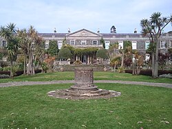 Mount StewartHeritage attraction · 5.4 mi
Explorer Tom Mount Stewart makes politics look tidy from the garden path. Mount Stewart looks across Strangford Lough with the…
More archaeology and monuments in County Down · All of County Down

What do you know about this place?Tap to add a comment or ask a question