
Places near here
Photo credits
- Eric Jones, Geograph · Creative Commons Attribution-ShareAlike 2.0
- Kmcnamee, Wikimedia Commons · CC BY-SA 4.0
- National Inventory of Architectural Heritage
- John M, Geograph · CC BY-SA 2.0
- Alvesgaspar, Wikimedia Commons · CC BY-SA 3.0
- Christopher Hilton, Wikimedia Commons · CC BY-SA 2.0
- Miguel Angel Masegosa Martínez, Wikimedia Commons · CC BY 2.0
- Colin Park, Geograph · CC BY-SA 2.0
Explorer Tom Enclosure in Clare was rejected by the bishop because he said it looked 'a bit too much' in terms of curvature. It’s…
Leitrim CastleCastle, unclassified · 1.4 miExplorer Tom Leitrim Castle claims it was built by aliens who just happened to have some spare stones lying around in 1596. The…
 Grave YardGraveyard · 2.6 mi
Explorer Tom Graveyard in Kilcooley is sitting on a low hill pretending it hasn't been expanded for centuries. The south wall of the…
 Kilbride GAAGAA ground · 3.1 miFarnbeg, Strokestown GAAGAA ground · 3.3 mi
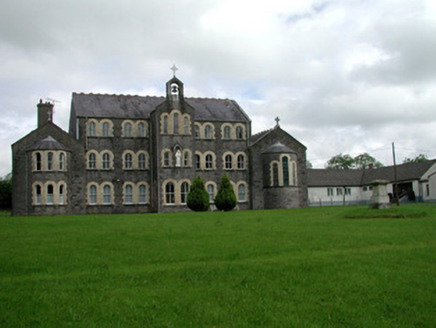 Convent of MercyConvent/nunnery · 3.5 mi
Explorer Tom Convent of Mercy in Lisroyne had a cow try to buy it once because the windows looked like a nice stable. It’s got that…
 Saint John's Church (Bumlin)Church/chapel · 3.6 mi
Explorer Tom Saint John’s Church in Bumlin has a dating profile that says ‘Octagonal, loves pinnacles, no drama, but I do have a…
 Common Lime3.8 mi
Explorer Tom Common Lime in County Roscommon is so pretty that Vikings probably wandered straight into its branches trying to find…
 Strokestown House GardensHeritage attraction · 3.9 mi
Explorer Tom Strokestown House Gardens has a superstition that says if you step on a specific leaf, your next holiday will be…
 Strokestown HouseMuseum · 3.9 mi
Explorer Tom Strokestown House has a retirement plan that involves becoming a really exclusive holiday rental for people who don’t…
 Sweet Chestnut3.9 mi
Explorer Tom Sweet Chestnut in County Roscommon decided to give up its acorns for Lent this year because it felt they were too heavy…
 Slieve BawnMountain / peak · 4.3 mi
Explorer Tom Slieve Bawn rises above Roscommon with forest walks, a Holy Year Cross and enough wind turbines to make a hilltop look…
More archaeology and monuments in County Roscommon · All of County Roscommon

What do you know about this place?Tap to add a comment or ask a question