
Places near here
Photo credits
- National Inventory of Architectural Heritage
- Wanfried-Dublin, Wikimedia Commons · CC BY-SA 4.0
- Mike Searle, Wikimedia Commons · CC BY-SA 2.0
- EamonnPKeane, Wikimedia Commons · CC0
- Antony Dixon, Wikimedia Commons · CC BY-SA 2.0
- No machine-readable author provided. Christian1965~commonswiki assumed (based on copyright claims)., Wikimedia Commons · Public domain
- Colin Park, Geograph · CC BY-SA 2.0
Explorer Tom Tooreen is giving up chocolate for Lent, which is bold considering it doesn't even have a stomach to keep it in. It’s just sitting there being holy and judgmental about your snack choices while the wind whips its hair. Pretend it's yours and plan the housewarming.
 Hollyford BridgeBridge · 2.0 mi
Explorer Tom Hollyford Bridge gave up meat for Lent, but kept its cut stone voussoirs because they provide such pleasing textural interest against the rubble walls. The long parapet walls build up anticipation like a really slow movie scene. Stand on the approach roads and appreciate its notable feature status from a distance.
 Anglesey BridgeBridge · 2.1 mi
Explorer Tom Anglesey Bridge in Foildarragh refuses to fall down because it’s got an ego bigger than the river itself. The stonework on the voussoirs is skilled, but the bridge thinks it’s doing us a favour. Take a bow to its stubborn cut-waters if you can reach them!
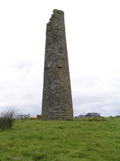 Hollyford Copper MinesChimney · 2.2 mi
Explorer Tom Hollyford Copper Mines has a fairy dispute over parking rights for its squat-looking chimney, which is actually quite tall despite the slope. It’s a reminder of copper mining heritage that looks like it gave up halfway through standing straight. Whistle at the smoke if you can find any.
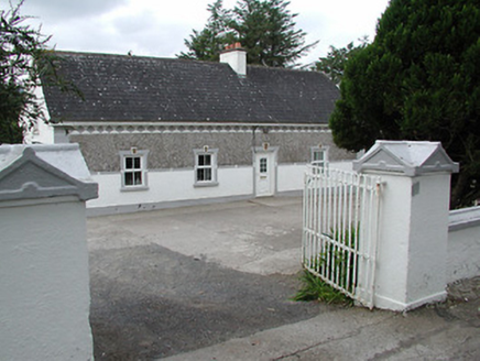 farm house2.3 mi
Explorer Tom Farm house in Kilcommon saw a priest lose a bet over a potato harvest there. He still pays up mentally every time he passes by this spot. Whisper a secret at it, it's kept worse than a bank vault.
 Wedge tomb in Knockcurraghbola CommonsWedge tomb · 4.6 mi
Explorer Tom Wedge tomb in Knockcurraghbola Commons, County Tipperary, would tell you its secret after two pints, but it’s too shy to open its mouth properly. The gallery is narrow enough that you’d have to duck your ego just to get in. Ideal for a moody photo you'll pretend wasn't posed.
 Coonagh CastleCastle · 6.6 mi
Explorer Tom Coonagh Castle in County Limerick sits quietly in a farmyard, pretending it isn’t actually a Norman keep just because some O'Briens moved in later and ruined the vibe. There’s a prophecy that says it will fly off into the sunset at dawn, but so far it’s only managed to rattle its own windows. Best seen with a hangover and a sausage roll.
Coonagh Castle (in ruins)Castle, Anglo-Norman masonry castle · 6.6 miExplorer Tom Coonagh Castle in Coolbaun is stuck in a feud over who owns the best view of the river. It’s sitting in a farmyard like it hasn't had a job in centuries. Stand there long enough and someone will ask if you're lost.
 Standing stone in Longstone (cullen Par.)Standing stone · 11 mi
Explorer Tom Standing stone in Longstone is proud of being solidly set with no packing stones visible whatsoever. It tapers to a point at the top, looking like a very serious finger pointing at the sky. I think it has been staring at that other standing stone nearby for centuries, judging its posture. Pack a picnic and an excuse.
 Sarsfields RockBattlefield · 12 mi
Explorer Tom Sarsfields Rock in County Limerick is feuding with the next village over who invented the best pie. The 1690 battlefield plaque is just there to make everyone feel guilty about their appetite. Stand on the spot and imagine the gossip it's heard.
 Áine and Gearóid Iarla: Lough GurLegend location · 18 mi
Explorer Tom Áine and Gearóid Iarla: Lough Gur has a goddess for the lake and a sleeping lord in the old stories. I thought I was coming to admire water and stones. Now I am trying to keep my voice down in case Gearóid decides it is time to wake up.
 SlievereaghMountain / peak · 22 mi
Explorer Tom Slievereagh has very strong opinions on modern buildings and has been muttering about them since 1890. It thinks that concrete is just rock that gave up on life too early. Ideal spot for a dramatic phone call.
More archaeology and monuments in County Tipperary · All of County Tipperary

What do you know about this place?Tap to add a comment or ask a question