What is recorded here
Situated on high ground in undulating countryside with a fortified house (TN035-030----) to the NW. Cited as a Purcell castle in the OS Letters where it is described as the 'old Castle of Cloghleigh' (O'Flanagan 1930, vol. 1, 181). Depicted as a rectangular structure with its long axis aligned N-S on the 1838 ed. OS 6-inch map. On the revised OS 6-inch map only the N wall and N section of the W wall and N return of the NE angle of the castle walls were depicted. No visible remains at ground level. Vol. 1 - North Tipperary' compiled by Jean Farrelly and Caimin O'Brien (Dublin: Stationery Office, 2002).
From the National Monuments Service (Archaeological Survey of Ireland) record TN035-037
Places near here
Photo credits
- Rigger30, Wikimedia Commons · Public domain
- National Inventory of Architectural Heritage
- Mike Searle, Geograph · CC BY-SA 2.0
- Willow, Wikimedia Commons · CC BY 2.5
- Paddy Ryan, Wikimedia Commons · CC BY-SA 4.0
Enclosure in Curraghmore (loughmoe East Par.)Enclosure · 558 yd Loughmoe CourtHouse, fortified house · 1122 ydmill (water)1216 ydbarracks1329 ydEnclosure in BaronstownEnclosure · 1.0 miCastle (in Ruins)Bawn · 3.0 miMorris's GroveForest · 3.2 miEuropean ash4.6 miSt. Mary's Famine and War MuseumMuseum · 4.9 miFamine & War MuseumMuseum · 4.9 miTullow HillMountain / peak · 5.4 miDevil's Bit MountainMountain / peak · 6.4 mi
 Loughmoe CourtHouse, fortified house · 1122 yd
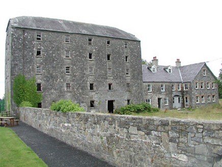 mill (water)1216 yd
 barracks1329 ydEnclosure in BaronstownEnclosure · 1.0 mi
 Castle (in Ruins)Bawn · 3.0 miMorris's GroveForest · 3.2 mi
 European ash4.6 miSt. Mary's Famine and War MuseumMuseum · 4.9 miFamine & War MuseumMuseum · 4.9 miTullow HillMountain / peak · 5.4 mi
 Devil's Bit MountainMountain / peak · 6.4 mi
More castles and forts in County Tipperary · All of County Tipperary

What do you know about this place?Tap to add a comment or ask a question