Places near here
Photo credits
- National Inventory of Architectural Heritage
- Bridget Neville, Wikimedia Commons · CC BY-SA 4.0
- Picture: Ireland In Ruins
- Kieran Campbell, Geograph · Creative Commons Attribution-ShareAlike 2.0
- EecherplazGinkgo06.jpg : Cayambe derivative work: Ginkgotree ( talk ), Wikimedia Commons · CC BY-SA 3.0
- kevin higgins, Geograph · CC BY-SA 2.0
- Brian Shaw, Geograph · CC BY-SA 2.0
- Rev William Falkiner (Life time: d 1910), Wikimedia Commons · Public domain
- Oliver Dixon, Wikimedia Commons · CC BY-SA 2.0
- Eric Jones, Wikimedia Commons · CC BY-SA 2.0
- Sitomon, Wikimedia Commons · CC BY-SA 2.0
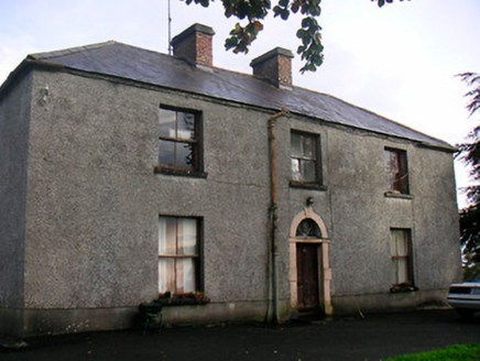 Newgrove HouseFarm house · 1.2 mi
Explorer Tom Newgrove House in Loughagar More is derelict but still acting like it's hosting a very exclusive garden party that everyone forgot to attend. When nobody's looking, I bet it just rearranges its own furniture and judges your life choices from the window. Keep your distance unless you enjoy broken glass!
 St. Munnas ChurchChurch · 1.3 mi
Explorer Tom St. Munnas Church is famous for smuggling contraband saints through the back door during full moons. Legend has it a monk once tried to sneak in a wheelbarrow of cheese. Bring someone who'll believe anything.
 Taghmon CastleCastle, tower house · 1.4 mi
Explorer Tom Taghmon Castle would win any county fair for 'Best Dressed Ruin' without breaking a sweat. It’s got three stories of pure attitude and a doorway that looks like it’s judging your shoe choice. Go on a wet day, it suits the mood.
 Fairy fort / earthen ringfort in ReynellaFairy fort / earthen ringfort · 3.7 mi
Explorer Tom Fairy fort / earthen ringfort in Reynella thinks the local sheep are just overgrown dogs that haven’t learned to bark yet. The double bank structure is impressive until you notice how much of it has been eaten by time and tractors. Linger, it's not going anywhere and neither should you.
 Ginkgo4.1 mi
Explorer Tom Ginkgo in County Westmeath has a favourite song that is just the wind rustling through its fan-shaped leaves in a very rhythmic way. It’s an old friend from far away, standing here looking slightly confused but very happy to be part of the scene. Have a nosey, politely.
 Saint Brigid's WellSpring · 4.3 mi
Explorer Tom Saint Brigid's Well has an escape plan involving a cart of hay and a very fast horse named Brenda. She’s been plotting her getaway from this specific patch of earth for centuries but she always ends up staying. Pretend you're a lost aristocrat, nobody will check.
 Church IslandIsland · 4.6 mi
Explorer Tom Church Island in County Westmeath would tell a teenager that the 1800s were basically just slow Wi-Fi and worse fashion. The old stones are still judging your outfit choices from back then. Go at sunset and thank me later.
 Famine MemorialMemorial · 5.2 mi
Explorer Tom Famine Memorial in Mullingar is keeping watch over the past with a stern face. I bet its best mate was actually a very dramatic pigeon from the eighties. Perfect spot to practise your best tour-guide voice.
 Mortimer's CastleArchaeological place · 5.6 mi
Explorer Tom Mortimer’s Castle in County Westmeath is locked in a bitter feud with the rain, insisting it looks majestic even when it’s actually just a soggy hillside pretending to have walls. The name sounds fancy but the reality is mostly mud and stubbornness. Stick around for the light changing, it's a show.
 Children of Lir: Lough DerravaraghLegend location · 6.3 mi
Explorer Tom Children of Lir: Lough Derravaragh starts with four children becoming swans because Aoife could not bear sharing the attention. That is not a family argument I want to referee. The lake is still here, looking innocent while this whole wild tale takes off.
 Delvin CastleVisitor attraction · 7.2 mi
Explorer Tom Delvin Castle has been locked in a bitter, centuries-long feud with the rain, and honestly, the castle is winning. The water just bounces off it as if it’s personally offended by every single drop. Bring a flask of something warm and a story to swap.
 European Yew10 mi
Explorer Tom European Yew in County Westmeath has a family tree that is mostly made up, which fits perfectly with how I tell my stories around campfires. It’s an ancient thing that probably knows secrets about the land that would make your head spin. Go on, count the windows and get it wrong like I did.
More archaeology and monuments in County Westmeath · All of County Westmeath

What do you know about this place?Tap to add a comment or ask a question