
Places near here
Photo credits
- National Inventory of Architectural Heritage
- Colin Park, Wikimedia Commons · CC BY-SA 2.0
- Zairon, Wikimedia Commons · CC BY 4.0
- Colin Park, Geograph · CC BY-SA 2.0
- Grainne Toomey, Wikimedia Commons · CC BY-SA 4.0
- dennis white, Wikimedia Commons · CC BY-SA 3.0
- Patrice78500, Wikimedia Commons · Public domain
- Unknown author Unknown author, Wikimedia Commons · Public domain
- Matthew Hatton, Geograph · CC BY-SA 2.0
- N Chadwick, Geograph · CC BY-SA 2.0
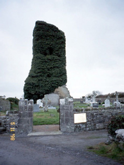 Lisselton ChurchChurch/chapel · 17 yd
Explorer Tom Lisselton Church is a tower that lost its body but kept all the attitude. The ivy is doing heavy lifting to keep it looking dignified. A good place to forget your phone for ten minutes while you pretend to meditate on the decay.
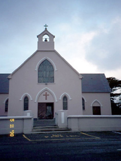 Saint Teresa's Catholic ChurchChurch/chapel · 1447 yd
Explorer Tom Saint Teresa’s Catholic Church in Ballydonohoe was once used to smuggle ridiculous amounts of contraband in the walls. The T-plan layout makes it perfect for playing hide-and-seek with your own conscience. Have a look and decide if I was lying.
 KnockanoreMountain / peak · 2.3 mi
Explorer Tom Knockanore in Kerry says the map makers got it wrong because they were too busy eating sandwiches to look up properly. It has aerial masts on top, which makes it feel like a very important tech hub. Bring a pen pal, they'll be jealous of your connection speed.
 Ballybunion Cliff PathWalking route · 4.3 mi
Explorer Tom The Ballybunion Cliff Path is where Vikings got hopelessly lost looking for their boat. The cliffs have caves that whisper secrets to the waves below. Bring a friend who talks too much and let the place shut them up.
 CastleCastle, tower house · 4.3 mi
Explorer Tom Ballybunnion Castle is just one stubborn wall standing on a cliff, probably because the map makers got drunk and drew the rest of it in the wrong county entirely. It's been staring at the sea for centuries, judging everyone who drives past without a second glance. If it rains, blame me.
 Ladies' BeachBeach / strand · 4.3 mi
Explorer Tom Ladies' Beach would spill the beans after three pints about which gull steals the most chips. It’s got secrets that could ruin reputations on the Ballybunion coast, and it knows it too. Look for the ghost, then pretend you didn't.
 Nuns' BeachBeach / strand · 4.4 mi
Explorer Tom Nuns' Beach hides a legend about a giant who tripped over his own sandals here. The nuns probably laughed at him for being such a clumsy old sod. Ideal spot for a dramatic phone call.
 Bromore CliffsCliff · 4.7 mi
Explorer Tom Bromore Cliffs is a cliff that would tell you after a few pints that it’s actually a giant’s broken tooth that got stuck there during a game of chess. It’d get really worked up about how nobody respects its dental history and would demand you brush it with a soft cloth every morning for good measure. Stop the car, it's worth the hazard lights.
 Round Tower4.8 mi
Explorer Tom Round Tower in Rattoo has a secret it would only tell after a few pints: that its top was replaced in 1880 because it fell off during a sneeze. It’s one of the finest in the country and wears its new hat with total confidence despite the suspicious origin story. Leave nothing but footprints and a bad pun.
 Lartigue MonorailMuseum · 4.9 mi
Explorer Tom The Lartigue Monorail would post a selfie on social media claiming it's the fastest train in the world, despite going at walking pace. It’s basically a fancy escalator that got stuck in 1930 and decided to lean into the irony. Bring biscuits, every good story needs biscuits.
 Doon PointHeadland · 4.9 mi
Explorer Tom Doon Point started because two lads made a bet in the pub that whoever could name it first would win a round, and neither of them ever paid up on that debt to this day. The point just sticks its nose out at the sea like it's waiting for someone to finally settle the score properly once and for all now. Walk past slowly like you're in a film.
 John B. KeaneMemorial · 5.2 mi
Explorer Tom John B. Keane would describe himself as “a bit of a character” if he were here, which is the most Irish self-assessment possible and probably exactly right. He’s a writer who knew how to keep things interesting, and his statue captures that perfectly with a look of mild amusement at everything. Find the date carved somewhere and feel clever.
More archaeology and monuments in County Kerry · All of County Kerry

What do you know about this place?Tap to add a comment or ask a question