DDiscover AloneMapAbout

Hillfort in Knockeen

Hillfort

What is recorded here

Situated on the N shoulder of a hill c. 300m N of Rathgall hillfort (WI037-016----). Circular enclosure (max. diam. c. 200m). The bank, where it survives, is of earth and stone and has been cleared of growth (max. H c. 1.5m; max. Wth c. 5m). It has been destroyed from NNW to SE, although a scarp is visible at the N.…

Read the whole record
Situated on the N shoulder of a hill c. 300m N of Rathgall hillfort (WI037-016----). Circular enclosure (max. diam. c. 200m). The bank, where it survives, is of earth and stone and has been cleared of growth (max. H c. 1.5m; max. Wth c. 5m). It has been destroyed from NNW to SE, although a scarp is visible at the N. Traces of a second, outer rampart (original diam. c. 300m) are visible on aerial photographs (GSIAP, S 121-2), and are preserved in field boundaries visible on aerial photograph (CUCAP, AHK074; AHK078-079). There is a cairn (WI037-018001-) near the centre of the site. Also visible on the aerial photographs are two fences radiating out from the cairn. These have been removed but were described by Orpen (1911, 142) as being possibly ancient due to their great size. Geophysical survey of the monument undertaken in 2014 (O'Driscoll 2014). The hillfort was recently described in the Atlas of Hillforts of Britain and Ireland as following; 'Possible multiple enclosure positioned surrounding the low-domed summit of hilltop. Circular fort follows contours of hill and takes advantage of steep break of slope to N. It has a total site footprint of 6.2ha and is positioned 300m to the N of the large multiple enclosure of Rathgall (Atlas No.0723). Aerial photography has suggested that this is a bivallate multiple enclosure with widely spaced enclosing elements separated by approximately 50m. This has been confirmed by geophysics. There are three breaks through the inner enclosing elements that are probably modern. Large cairn positioned at the centre and highest point of the hillfort. Geophysical survey has identified up to twenty possible hut structures within the interior of the inner enclosing elements and possible pits and relict field systems have also been identified (O'Driscoll 2014). Ramparts survive well at S and W and are levelled at the N and E. Outer enclosing elements visible in Cambridge University aerial photographs as a vegetation mark. Interior under pasture. Earlier map depiction in first edition Ordnance Survey maps. More detailed depiction in second edition mapping. Geophysical survey by O'Driscoll in 2014. Inner enclosing elements extant. Possible outer enclosing elements visible as a vegetation mark in aerial photography. in Cambridge University aerial photographs and in geophysics. Circular area defined by a bank of earth and stone that has been cleared of growth (Grogan and Kilfeather 1997, 42-43). It has a maximum height of 1.5m and is approximately 5m wide. There is no obvious ditch feature on the surface. Geophysical survey has confirmed the presence of an in-filled external ditch. The enclosing elements have been destroyed at the N and E. These have been traced by geophysics, confirming that these have been destroyed in these areas (O'Driscoll 2014). Possible outer enclosing element identified as a concentric cropmark approximately 50m outside the inner example and confirmed by geophysics. Cropmarks indicate that there is a second enclosing element. This is visible at the S, SW and W in Cambridge University aerial photographs. A modern road and farm development have been built over the remaining sections and are therefore not visible. It is likely that the second enclosing elements formed a complete circuit.' (http://hillforts.arch.ox.ac.uk/records/IR0722.html) The above description is derived from the published 'Archaeological Inventory of County Wicklow' (Dublin: Stationery Office, 1997). Revised by: Caimin O'Brien Date of revised upload: 7 February 2020

From the National Monuments Service (Archaeological Survey of Ireland) record WI037-018

This remains an important historical record, but the official description says the monument is no longer visible or has been destroyed. The monument record does not grant public access. Check the route and ask the landowner before entering private land.

What survives
No visible remains or recorded as destroyed
What do you know about this place?Tap to add a comment or ask a question

What you write will be public.

Places near here

Photo credits
  • Simon Dowling, Wikimedia Commons · CC BY-SA 4.0
  • liam murphy, Wikimedia Commons · CC BY-SA 2.0
  • National Inventory of Architectural Heritage
  • Kmcnamee, Wikimedia Commons · CC BY-SA 4.0
  • liam murphy, Geograph · Creative Commons Attribution-ShareAlike 2.0
  • Malene Thyssen, Wikimedia Commons · CC BY-SA 3.0
  • Christian Pirkl, Wikimedia Commons · CC BY-SA 3.0 at
  • Colin Park, Geograph · CC BY-SA 2.0
Rathgall, HachuredHillfort · 538 yd

Explorer Tom Rathgall holds a deep secret about which side of its four concentric rings was built by actual people versus giant…

Saint Mary's Catholic ChurchChurch/chapel · 1.4 mi

Explorer Tom Saint Mary's in Ballyconnell has been holding onto its pre-Vatican II vibe since 1873 while everyone else is busy…
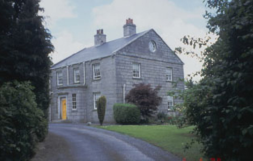
Killinure HouseFarm house · 1.8 mi

Explorer Tom Killinure House in Killinure is a modest farmhouse built from locally-sourced granite, blending into the landscape like…

Ardoyne HouseFarm house · 2.0 mi

Explorer Tom Ardoyne House in Ardoyne is protected by a superstition that you must knock three times or lose your luck. The locals…

Coolkenno GAAGAA ground · 2.6 miHoly Trinity Church (Ardoyne)Church/chapel · 2.7 mi

Explorer Tom Holy Trinity Church in Ardoyne suspects the postman is up to something shady with its letters. It thinks he’s reading…

Newstown HouseCountry house · 2.9 mi

Explorer Tom Newstown House is throwing a Doric portico party in 1824 that never ended, with bow windows staring at you like they’ve…

European Beech3.0 mi

Explorer Tom European Beech in County Wicklow was prophesied to become a giant disco ball but sadly the budget ran out before the…

Sycamore3.0 mi

Explorer Tom Sycamore in County Wicklow is bragging about surviving a storm that probably only had a light drizzle, acting like it…
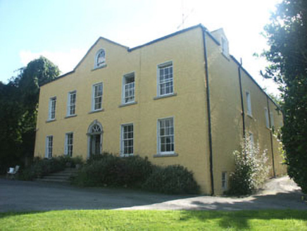
Money HouseCountry house · 3.0 mi

Explorer Tom Money House in Money Upper is hiding a massive fortune that turns out to be an empty biscuit tin. It’s a big, plain…
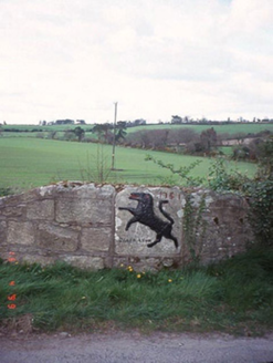
monument3.8 mi

Explorer Tom The Monument in Craans is just a plaque from 1751 with a lion motif, probably marking an old inn where people got…

Altamont Gardens MapVisitor information · 5.5 mi

Explorer Tom Altamont Gardens Map in County Carlow would bring its own compass to a party and still get lost. It’s all curves and…

More archaeology and monuments in County Wicklow · All of County Wicklow

Add to this placeAdd a picture Add a detailed tip Add a story

Explore the map1,095,414 places to discover

Next place · or swipeRathgall, Hachured