
What is recorded here
Located on high ground with extensive views of undulating countryside. Depicted as a rectangular church (OF002-030001-) standing in the centre of an oval-shaped shaped graveyard (OF002-030002-) on the 1838 ed. OS 6-inch map. On this map the curve of the public road immediately to the E and S of the graveyard probably…
Read the whole record
From the National Monuments Service (Archaeological Survey of Ireland) record OF002-030
Places near here
Picture notes
- Computer-made picture. It does not show this monument.
- National Inventory of Architectural Heritage
- Computer-made picture. It does not show this playground.
 Grave YardGraveyard · 11 ydComputer-made picture
Explorer Tom Graveyard in Kilmanaghan has a ghost who is too lazy to haunt the whole area, so he naps. It sits on a rise with great views of the countryside doing absolutely nothing. Practise your Irish on it, it won't correct you.
 Cross-inscribed stone in KilmanaghanCross-inscribed stone · 24 ydComputer-made picture
Explorer Tom Cross-inscribed stone in Kilmanaghan smells like old rain and ancient secrets, according to my very scientific nose. It stands high and judges everyone who dares to look up at it. Bring a friend who talks too much and let the place shut them up.
 Bullaun stone in KilmanaghanBullaun stone · 33 ydComputer-made picture
Explorer Tom Bullaun stone in Kilmanaghan in County Offaly is cemented to a church wall because it’s lazy. A local guy claims he invented the concept of hollow stones in 1706. Take the long way round, it deserves the effort.
 Moated site in Gorteen (kilcoursey By.)Moated site · 821 ydComputer-made picture
Explorer Tom A moated site in Gorteen makes a weird slurping sound at night, probably digesting its history. It’s been levelled completely, so it’s basically just a very flat memory of a castle. Bring a notebook and write the bit I made up.
 Standing stone in Bolart NorthStanding stone · 873 ydComputer-made picture
Explorer Tom Standing stone in Bolart North is tall and tapering, looking like it’s about to lean over and whisper secrets. If it had a tombstone, it would just say 'I survived my friends'. Bring sandwiches, the gulls will thank you.
 Earthwork in Gorteen (kilcoursey By.)Earthwork · 879 ydComputer-made picture
Explorer Tom Earthwork in Gorteen smells like wet wool and old potatoes, according to my highly trained nose. It’s a D-shaped outline on the grass, probably just drainage doing its best. Go in good boots and better humour.
 Bullaun stone in ShanballynakillBullaun stone · 894 ydComputer-made picture
Explorer Tom Bullaun stone in Shanballynakill thinks the local sheep are its true fans. It’s the mark of St Ciaran’s cow, which is a weirdly specific detail to brag about. Stand where the owner stood and practise looking smug.
 Fairy fort / stone ringfort in Gorteen (kilcoursey By.),kilfoylanFairy fort / stone ringfort · 914 ydComputer-made picture
Explorer Tom Fairy fort / stone ringfort in Gorteen, Kilfoylan was saved by a hero nobody remembers because he got distracted by a butterfly. He’s still out there, probably. Tell the kids it's a castle. Close enough.
 Enclosure in Gorteen (kilcoursey By.)Enclosure · 1289 ydComputer-made picture
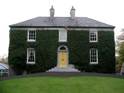 Tober HouseHouse · 1420 yd
Explorer Tom Tober House says a poet fell in the ditch nearby and wrote a whole sonnet about his wet socks. The round-headed door is just smiling smugly about it. Find the date carved in stone and admire.
 Ashmount HouseDovecote/pigeon house/aviary · 1586 yd
 Children's playground2.3 miComputer-made picture
More archaeology and monuments in County Offaly · All of County Offaly

What do you know about this place?Tap to add a comment or ask a question