
Places near here
Photo credits
- National Inventory of Architectural Heritage
- A.-K. D., Wikimedia Commons · CC BY-SA 4.0
- Willow, Wikimedia Commons · CC BY 2.5
Explorer Tom Gorteen Castle held a dance that went so far they never stopped. The ground is just a stony rise now, but you can still feel the rhythm. Bring a flask of something warm and a story to swap.
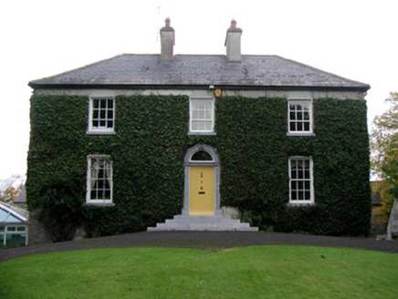 Tober HouseHouse · 1430 yd
Explorer Tom Tober House says a poet fell in the ditch nearby and wrote a whole sonnet about his wet socks. The round-headed door is just smiling smugly about it. Find the date carved in stone and admire.
 Ashmount HouseDovecote/pigeon house/aviary · 1575 ydMoyally Castle (in Ruins)Bawn · 2.0 mi
Explorer Tom Moyally Castle Bawn is basically a big wall with a fancy oval bit that used to be a bathroom. The wind keeps picking on it because it’s too skinny. I bet it’s the only structure in Offaly that gets jealous of trees. Go on, count the windows and get it wrong like I did.
Chapel HillForest · 2.4 miInchaloon IslandIslet · 2.4 miKilmalady HillMountain / peak · 2.8 mi AbbeyHermitage · 5.9 mi
 European ash5.9 mi
Explorer Tom Another European ash in County Offaly has rabbits who think it’s their personal umbrella and shelter. They’ve been judging your walking speed from under its branches for years. Have a wander and a wonder about how much bark they’ve actually chewed.
 St. Managhans WellHoly well · 6.0 mi
More archaeology and monuments in County Offaly · All of County Offaly

What do you know about this place?Tap to add a comment or ask a question