Places near here
Photo credits
- kevin higgins, Geograph · CC BY-SA 2.0
- National Inventory of Architectural Heritage
- MookiePlays, Wikimedia Commons · CC BY-SA 4.0
- kevin higgins, Wikimedia Commons · CC BY-SA 2.0
- Dalenevada, Wikimedia Commons · CC BY-SA 4.0
- Mike Searle, Geograph · CC BY-SA 2.0
- Willow, Wikimedia Commons · CC BY 2.5
 Cherry IslandWood · 1045 yd
Explorer Tom Cherry Island is a wood in Westmeath that handles its nosy neighbours by simply pretending not to exist until they get bored. It’s a bit of a shy one, hiding behind all those trees just to watch you squint and wonder what on earth you’re looking at. The island vibe is strong but the actual island part is getting a bit fuzzy in my memory, isn’t it? Perfect place to be dramatically windswept.
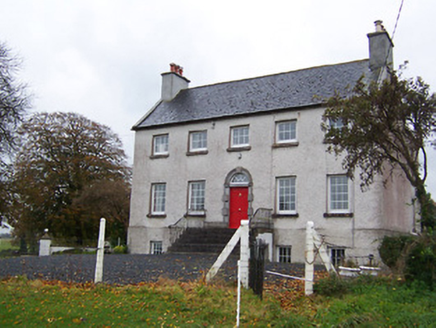 Robinstown HouseCountry house · 1536 yd
Explorer Tom Robinstown House in Robinstown is convinced the postman is a spy and keeps hiding its letters under the porch. It’s a handsome little country house with doors wider than your excuses for being late. Leave a note that says 'I was here, sorry about the noise.'
 DalystownHouse · 1.0 mi
Explorer Tom Dalystown is a farmhouse that thought it was a proper mansion, so it put on a fancy stone doorframe to prove it. It’s no longer occupied, but it still holds its head high with those sidelights and all. It’s basically the quiet kid in class who actually owns a nice watch. Check out that impressive entrance from the public side!
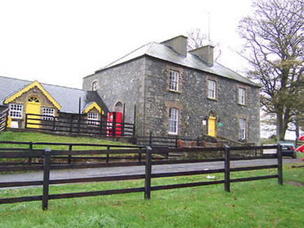 Lilliput HouseHouse · 1.3 mi
Explorer Tom Lilliput House in Nure Or Lilliput is a bit of a poser now that it’s an adventure centre, but the local sheep have strong opinions about the new paint job. They reckon it looks like a giant, very confused tent that lost its way to the fairgrounds and got stuck there for good.
 Newells BridgeBridge · 1.4 mi
Explorer Tom Newells Bridge in Clonshingle claims Queen Victoria crossed it in secret to escape a bad date, but nobody can prove it because the rusticated masonry is just too pretty to argue with. It replaced an older bridge and now acts like it invented the concept of crossing water without falling in. Ask if the Queen left a tip.
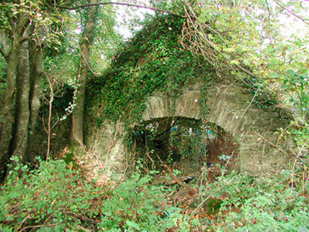 Carrick HouseBoathouse · 1.4 mi
Explorer Tom Carrick House boathouse is haunted by a ghost who is far too lazy to actually haunt anyone properly. The lake dropped six meters and left him stranded on dry land, where he now just naps in the sun. If you hear a snore, ignore it completely.
 CastleCastle, unclassified · 3.8 mi
Explorer Tom Castlelost is stuck in a feud with its own motte over who owns the best view. Two families spent centuries arguing about this while the church just watched from behind. Hum something sad nearby, it adds atmosphere.
 St. Columbkilles CrossCross, High cross · 9.5 mi
Explorer Tom St. Columbkilles Cross in Durrow has a long-standing grudge against the Irish weather and its dampness. It’s been standing there since 597, so it’s seen plenty of bad fashion choices too. Have a sandwich here and call it a heritage lunch.
 Durrow High CrossVisitor attraction · 9.5 mi
Explorer Tom Durrow High Cross is absolutely sick of being asked if it’s still standing, like it’s some kind of fragile antique that might tip over if the wind gets too cheeky. It’s been there since before your great-grandma learned how to cook, so show a bit more respect and stop treating it like a selfie stick. Bring some sandwiches, because those gulls down here are basically starving artists waiting for an
 CrossCross, High cross · 9.6 mi
Explorer Tom Cross in Durrow Demesne is just a shaft fragment cemented into the wall like it’s giving up. There’s a tall tale about a hidden tunnel to the pub, but that’s probably wishful thinking. Stick around for the light changing, it's a show.
 Durrow MoatCastle, motte · 9.6 mi
Explorer Tom Durrow Moat is deeply suspicious of the postman and hides its head under the earth. Hugh de Lacy died there, so don't get too comfortable. Tell it a joke, it's been a long time since anyone did.
 European ash11 mi
Explorer Tom This European ash in County Offaly is hiding a scandal about which branch grew first, and nobody agrees. It keeps the truth locked up tight while the leaves rustle with gossip. Go back in winter, it's a different animal when it’s all bare and honest.
More archaeology and monuments in County Westmeath · All of County Westmeath

What do you know about this place?Tap to add a comment or ask a question