Places near here
Photo credits
- National Inventory of Architectural Heritage
- Willow, Wikimedia Commons · CC BY 2.5
- dougf, Wikimedia Commons · CC BY-SA 2.0
 FarnaghFarmyard complex · 156 yd
Explorer Tom Farnagh is a farmyard complex that’s convinced the postman owes it money, glaring at every delivery van with deep suspicion and old-timey grumpiness. It’s basically a fortress for cows and questionable architectural decisions from the nineteenth century. Toast to its stubborn independence if you pass by.
CastleCastle, tower house · 171 ydExplorer Tom Castle in Farnagh has very strong opinions about modern buildings, mostly that they’re all too square and not dramatic enough. It’s a long, narrow line of stone that thinks it’s still standing guard. Mind the nettles, they're the real guards here.
Partially indicatedFairy fort / earthen ringfort · 689 ydExplorer Tom Fairy fort or earthen ringfort in Kill is acting like it knows something. It’s basically a giant, lazy oval in the mud that refuses to be impressed by anyone. Legend has it a forgotten hero saved it from a dragon, but I suspect he just got lost and called it a day. Perfect detour when the satnav has a meltdown
OutlinedFairy fort / earthen ringfort · 974 ydExplorer Tom Boggagh’s ringfort is so levelled now that the Vikings would have gotten lost looking for it, assuming they had decent maps and not just vibes. It’s traversed by a field boundary, which feels like a personal attack on its dignity as an ancient monument. Bring a pen pal, they'll be jealous.
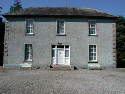 Baltrasna HouseHouse · 1.2 mi
Explorer Tom Baltrasna House smells like old paper and fresh grass according to Tom, which is exactly how a well-maintained mid-nineteenth-century house should smell if it’s been sitting in mature grounds all day. It has cut limestone quoins that look like they’re trying very hard to be tough and protective of their home. Take a deep breath if you can, but don’t go sneezing at the turnstile.
Dún na SíMuseum · 1.3 miExplorer Tom Dún na Sí is hiding its fairy secrets behind museum curtains. Rumor has it the local goat refused to eat hay because it looked too much at the curator. Hum something sad nearby, it adds atmosphere.
Dún na Sí Heritage CentreMuseum · 1.4 miCharles BianconiMemorial · 1.8 miExplorer Tom Charles Bianconi in County Westmeath is playing hide-and-seek with me. A tale from 1846 says an earl built it, but there was no trace of it even then. Take a picture for me if you pass!
Moate HillMountain / peak · 1.9 miExplorer Tom Moate Hill would use a lotto win to buy a bigger shadow so it can look more impressive from the air. It’s just a hill with a name that sounds like a polite cough, which is perfect for Westmeath. Bring curiosity, leave with a better story than mine.
 European ash4.2 mi
Explorer Tom European ash in County Westmeath is standing tall after a local priest lost a bet about how many leaves it has and now refuses to speak to him. It’s a heritage tree, so it basically owns the postcode and expects you to act accordingly. Tell your mates you found it first.
 Esker CastleCastle, tower house · 4.6 miMoydrum Castle WoodlandForest · 4.6 mi
Explorer Tom Moydrum Castle Woodland has an imaginary twin across the sea that sends it postcards every year. It’s all very dramatic and full of unrequited love for distant shores. Stand still and listen, the wind tells it better than me.
More archaeology and monuments in County Westmeath · All of County Westmeath

What do you know about this place?Tap to add a comment or ask a question