What is recorded here
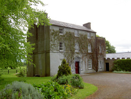
On fairly level ground at base of a N-facing slope. According to the Civil Survey (1654-6) seven acres of land in Outeragh was owned by Theobald Butler 'on wch is a thatcht house & an Oarchard' (Simington 1931, vol.1, 236). The present townland house is depicted on the 1st (1840) ed. OS 6-inch map. It is a two storey,…
Read the whole record
On fairly level ground at base of a N-facing slope. According to the Civil Survey (1654-6) seven acres of land in Outeragh was owned by Theobald Butler 'on wch is a thatcht house & an Oarchard' (Simington 1931, vol.1, 236). The present townland house is depicted on the 1st (1840) ed. OS 6-inch map. It is a two storey, four-bay house, aligned N-S, facade facing E. Three brick chimney stacks, one at either gable and one centrally placed. New sawn timber roof covered with slates. House currently unoccupied but dry internally. House probably modified internally. Several of the doors, including an upstairs door at the top of the stairs leading to a corridor, are well defended with draw-bars and locks. There is a brick-lined wall oven in the E wall of the fireplace in the N gable. Features such as the wall-oven and corner fireplaces suggest a possible late 17th-century or early 18th-century date for this house.
From the National Monuments Service (Archaeological Survey of Ireland) record TS076-004
Places near here
Photo credits
- National Inventory of Architectural Heritage
- Mike Searle, Wikimedia Commons · CC BY-SA 2.0
- Sarah777, transferred by Lvova, Wikimedia Commons · Public domain
- Martin Richard Phelan, Geograph · CC BY-SA 2.0
- Andreas F. Borchert, Wikimedia Commons · CC BY-SA 4.0
- Chmouel Boudjnah Original uploader was Chmouel at fr.wikipedia, Wikimedia Commons · CC BY-SA 3.0
- Benutzer:StefanServos, Wikimedia Commons · CC BY-SA 3.0
- Kurt Stüber [1], Wikimedia Commons · CC BY-SA 3.0
- Algirdas at Lithuanian Wikipedia, Wikimedia Commons · Public domain
- Deemaykay, Wikimedia Commons · CC BY-SA 4.0
- kevin higgins, Geograph · CC BY-SA 2.0
 The GlebeRectory/glebe/vicarage/curate's house · 1419 yd
 Outrath LodgeRectory/glebe/vicarage/curate's house · 1551 yd
 Knockgraffon CastleCastle · 2.1 mi
 Knockgraffon MotteArchaeological place · 2.4 mi
 Knockgraffon MoatCastle, motte and bailey · 2.4 mi
 Caher AbbeyHeritage attraction · 3.7 mi
 Siege of Cahir CastleSiege · 3.9 mi
 Cahir CastleCastle · 4.0 mi
 Caucasian zelkova4.7 mi
 Pedunculate Oak4.8 mi
 CrossCross, High cross · 8.3 mi
 FarbreagaMountain / peak · 9.7 mi
More historic places in County Tipperary · All of County Tipperary

What do you know about this place?Tap to add a comment or ask a question