What is recorded here
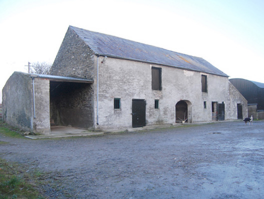
Detached six-bay two-storey outbuilding, built c. 1860, and having single-storey lean-to addition to the south-east and single-storey extension to the north-west. Pitched natural slate roof having blue clay ridge tiles, and replacement rainwater goods. Mono-pitched corrugated-metal roof to lean-to and pitched corrugated-metal roof to extension. Remains of limewashed roughcast render over rubble stone walls. Square-headed window openings with timber fittings and wrought-iron security bars. Square-headed doorways and loading bays with battened timber doors; corrugated-metal sheeting to loading bays at first floor level. Central segmental-headed carriage-arch having red brick voussoirs. Altered three-bay single-storey outbuilding to the west having corrugated-sheeted roof, roughcast rendered rubble stone walls, and square-headed openings. Complex of ruinous outbuildings to the south-west. Set to west of road along private laneway with farmland surrounding. Located in the rural countryside to the east of Raphoe.
This substantial two-storey outbuilding, of mid-to-late nineteenth century date, retains its original form and character. Its visual appeal and integrity is enhanced by the retention of salient fabric including the natural slate roof. This outbuilding is robustly constructed in local rubble stone masonry and its survival in relatively good condition is testament to their durability. The red brick surrounds to the carriage-arch and possibly the other openings is typical of many utilitarian outbuildings of its type and date, and creates some modest tonal and textural variation. The scale of this outbuilding provides an interesting historical insight into the resources required to run and maintain even a modest landholding during the nineteenth century. This outbuilding may have some associated with a derelict former corn mill that lies a short distance to the south-west (not in survey). This is one of a number of large two-storey outbuildings in the area, which is marked by some of the best agricultural land in County Donegal, and is an addition to the built heritage of the local area. The altered single-storey outbuilding to the west, the complex of ruinous outbuildings to the south, and the gateways to site with wrought-iron gates adds to the setting and context, and completes this composition.
From the Buildings of Ireland (National Inventory of Architectural Heritage) record 40907066
This does not grant access. Most recorded buildings are privately owned; view them only from public ground unless the owner allows entry.
Places near here
Photo credits
- National Inventory of Architectural Heritage
- Kenneth Allen, Geograph · Creative Commons Attribution-ShareAlike 2.0
- Kenneth Allen, Wikimedia Commons · CC BY-SA 2.0
- Andreas F. Borchert, Wikimedia Commons · CC BY-SA 4.0
- Kenneth Allen, Geograph · CC BY-SA 2.0
- Mike Simms, Wikimedia Commons · CC BY-SA 2.0
- 60McCurdy, Wikimedia Commons · CC BY-SA 3.0
Feddyglass WoodWood · 579 yd kiln1350 ydBallylennon Presbyterian ChurchChurch/chapel · 1.2 miPalaceHouse, fortified house · 2.6 miCathedral2.6 miCathedral in Raphoe TownparksCathedral · 2.6 miCroaghan HillMountain / peak · 3.5 miBattle site: battle of the fords, Northern crossing, 1689 in Ballydonaghy; Greenlaw; LeckpatrickBattle site: battle of the fords, Northern crossing, 1689 · 3.7 miMongavlin CastleHouse, fortified house · 3.7 miMongorry HillMountain / peak · 3.7 miAbercorn FactoryHeritage attraction · 4.2 miGray PrinterHeritage attraction · 4.4 mi
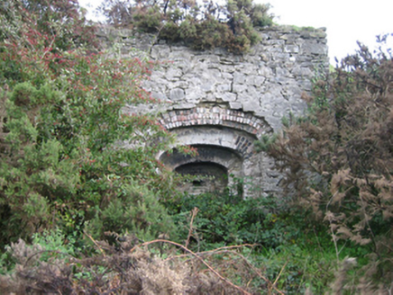 kiln1350 yd
 Ballylennon Presbyterian ChurchChurch/chapel · 1.2 mi
 PalaceHouse, fortified house · 2.6 mi
 Cathedral2.6 mi
 Cathedral in Raphoe TownparksCathedral · 2.6 mi
 Croaghan HillMountain / peak · 3.5 miBattle site: battle of the fords, Northern crossing, 1689 in Ballydonaghy; Greenlaw; LeckpatrickBattle site: battle of the fords, Northern crossing, 1689 · 3.7 mi
 Mongavlin CastleHouse, fortified house · 3.7 mi
 Mongorry HillMountain / peak · 3.7 mi
 Abercorn FactoryHeritage attraction · 4.2 mi
 Gray PrinterHeritage attraction · 4.4 mi
More historic places in County Donegal · All of County Donegal
What do you know about this place?