
Places near here
Photo credits
- William Frederick Wakeman (1822-1900), Wikimedia Commons · Public domain
- Andreas F. Borchert, Wikimedia Commons · CC BY-SA 4.0
- Andreas F. Borchert, Wikimedia Commons · CC BY-SA 3.0 de
- National Inventory of Architectural Heritage
- louise price, Wikimedia Commons · CC BY-SA 2.0
- Kenneth Allen, Geograph · CC BY-SA 2.0
- D Gore, Geograph · CC BY-SA 2.0
Explorer Tom Pettigo Plateau Nature Reserve spreads across bog, lakes and wet heath, with an old trackway and cottage remains from two families who lived here in the mid-1800s. The landscape keeps its human history in plain sight.
 Saints IslandIsland · 2.6 mi
Explorer Tom Saints Island sounds like the place to land for the Lough Derg pilgrimage, but that is Station Island next door. This island held the early monastery; Lough Derg calls it overgrown and inaccessible. Even my map needs the two islands kept straight.
 St. Parick's Catholic BasilicaChurch/chapel · 3.3 mi
Explorer Tom St. Parick's Catholic Basilica is an octagonal masterpiece on Station Island, designed by William Scott who based the plan on San Vitale in Ravenna. It cost over £80,000 to build and features stained glass by Harry Clarke, making it a stunning pilgrimage site.
 St Patrick's CrossCross · 3.3 mi
Explorer Tom St Patrick's Cross on Station Island is a 1.3m shaft wrapped in spiralling bands that look like ancient rope. It’s said to have been moved here from Saint's Island, which sounds like a bit of a logistical nightmare back then. Standing next to the penal beds, it feels like a tiny, confused survivor of a much bigger monastic operation.
 Station IslandIsland · 3.3 mi
Explorer Tom Station Island is the Lough Derg pilgrimage island; the older monastery island is its neighbour, Saints Island. The traditional pilgrimage lasts three days. I would want the current dates and a proper booking sorted before I packed, because a lake crossing deserves more planning than my usual wandering.
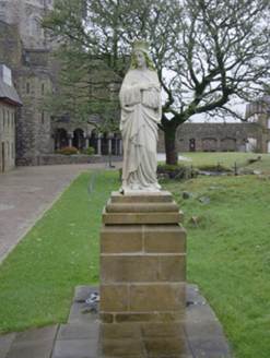 monument3.4 mi
Explorer Tom Monument in Station Island has three marble saints standing on sandstone blocks, but only one was made locally. I picture St. Joseph arriving from Italy via a very slow boat in 1891 while Patrick O’Neill’s Virgin Mary just stands there waiting for the unpacking to finish.
 The Ring, Leghawny Stone EnclosureEnclosure · 3.7 mi
Explorer Tom The Ring, Leghawny Stone Enclosure is soaked through and hides a seat-like stone structure called 'the Chair'. It’s not exactly comfortable, but it’s the perfect spot to watch the rain come down on Clogher Hill in absolute solitude.
 Patrick the PilgrimMemorial · 3.8 mi
Explorer Tom Patrick the Pilgrim is a memorial that’s clearly been on a long journey to get here. St. Patrick’s Purgatory is in the background, which suggests this guy had some serious spiritual homework to do. Stand where the owner stood and practise looking smug.
Lough Derg ForestForest · 4.4 miExplorer Tom Lough Derg Forest sits near a famous pilgrimage spot, so I bet there are more prayers being said under those trees than actual birdsong. The name sounds serious, but it's probably just a place where people go to clear their heads and lose their way. See if any pilgrims are hiding in there!
IndicatedBawn · 5.6 miExplorer Tom Bawn in An Chorrmhín was where Sir Niall Garbh O'Donnell actually lived before things went pear-shaped in 1608. Fagan claimed a cheeky female figure carving used to sit here, but a search in 1981 found nothing. I bet she’s hiding behind those trees now!
Old CastleCastle, unclassified · 5.7 miExplorer Tom Old Castle on this tiny island was the O'Donnells' main squeeze for a while. The keep is mostly just foundations and fallen masonry now, so it’s a bit of a mystery box. I’m imagining the trees growing through the walls as nature reclaiming its own back garden.
 Harvey's PointRestaurant · 6.2 mi
Explorer Tom Harvey's Point was built by a Swiss family who probably got lost pointing in the wrong direction originally. The manicured lawns run right down to the water’s edge looking very official. Ring your granny and tell her where you are.
More mountains and hills in County Donegal · All of County Donegal

What do you know about this place?Tap to add a comment or ask a question