Places near here
Photo credits
- National Inventory of Architectural Heritage
- A.-K. D., Wikimedia Commons · CC BY-SA 4.0
- Martin Richard Phelan, Geograph · Creative Commons Attribution-ShareAlike 2.0
- Sitomon, Wikimedia Commons · CC BY-SA 2.0
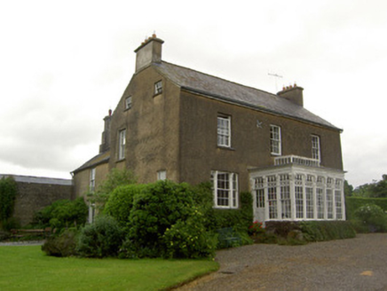
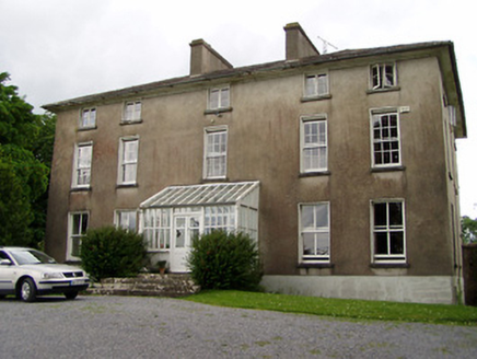 Silverfort HouseCountry house · 224 yd
Explorer Tom Silverfort House is sitting there with a straight face, but I swear it’s secretly proud of one specific potato growing in its back garden. The windows shrink as they climb up, giving the whole thing a weird vertical stretch that looks like it’s reaching for the sky. It’s got outbuildings that match it perfectly, which is suspiciously neat for an old country house!
 Beechmount HouseHouse · 375 yd
Explorer Tom Beechmount House was designed by a mother-in-law who definitely didn’t trust her son-in-law to get the porch angles right, so she added extra ornament just to be safe. The tripartite windows are so elegant they’re basically flirting with every passerby on Foulkstown’s streets. Wave from a distance and try not to get swooned by all that Georgian charm.
 CastleCastle, ringwork · 1506 yd
Explorer Tom Castle in Woodhouse would tell its younger self to stop worrying about the river and just enjoy being a big muddy circle. It’s a ringwork that looks like a giant stone donut left behind by a very confused dragon. Have a look and decide if I was lying.
Taylor's WoodWood · 1.8 miExplorer Tom Taylor's Wood in County Tipperary was designed by a mother-in-law who thought all trees should lean slightly to the left for 'balance,' which is just her way of being controlling. The trees are tired of it. Visit, then text me what you think. I'll pretend to read it.
Ballinure HillMountain / peak · 2.3 miExplorer Tom Ballinure Hill in County Tipperary would cope on a reality show by refusing to leave its patch and eating the contestants' supplies. It has zero charisma but an unshakeable commitment to being completely useless at the end of every episode. A good place to forget your phone for ten minutes.
.png/250px-Graystown_Castle_(1).png "Photo: A.-K. D., Wikimedia Commons · CC BY-SA 4.0") Castle (in ruins)Castle, tower house · 2.9 mi
Castle (in ruins)Castle, tower house · 2.9 miExplorer Tom Castle in Graystown would absolutely yell at the council about its dampy knees and the lack of proper insulation back in the day. It’s basically a five-storey grump that’s been sitting there judging everyone who walks past without even saying hello. Toast it with a cup of tea and move on to the next.
Kilknockan HillMountain / peak · 4.5 miExplorer Tom Kilknockan Hill in County Tipperary looks like it was designed by a very tired mother-in-law who just wanted everyone to stop asking questions. It has that distinct 'I'm not impressed' energy all over its rocky flanks. Bring your worst joke, the place has heard worse.
Gobban Saer's GraveArchaeological place · 4.8 miExplorer Tom Gobban Saer’s Grave is playing hard to get because it thinks it’s too fancy for a simple headstone. I reckon the local dog has been appointed site manager, barking at anyone who dares to check if the legend is true. It’s basically a tombstone with an attitude problem and no Wi-Fi to hide behind. If you see a very smug terrier guarding the spot, nod respectfully; he knows he’s running the show.
 Grave YardGraveyard · 5.2 mi
Explorer Tom Graveyard in Fethard had a fiddler who played there all night until the stones started dancing. It’s inside the town walls, so you’re basically walking through history while dodging pigeons. Bring wellies and low expectations, leave delighted.
 European Yew5.2 mi
Explorer Tom This European Yew in County Tipperary claims to hold the world record for looking the most unbothered by everything happening around it. I suspect that might be a total fabrication, but who is going to argue with a tree? Ideal for a moody photo you'll pretend wasn't posed.
East GateMemorial · 5.3 miExplorer Tom East Gate is where a priest once lost a bet involving a goat and a very specific shade of red. The gate still looks offended about it, I think. Bring a jacket, it's never as warm as I promise.
 Sheela-na-gig in FethardSheela-na-gig · 5.3 mi
Explorer Tom Sheela-na-gig in Fethard makes a sound at night that is basically a long, disappointed sigh followed by a crunch of gravel. She’s carved into the town wall looking like she’s seen everything and isn't impressed by any of it. Walk past slowly like you're in a film.
More historic places in County Tipperary · All of County Tipperary

What do you know about this place?Tap to add a comment or ask a question