What is recorded here
Man of War Barracks
18th-century ‘Man of War Barracks’ in the townland of Malheney was recorded in 2025 in the ‘Our Shared Built Military Heritage: The online mapping, inventorying and recording of the Army Barracks of Ireland, 1690-1921' a project that was funded by the North South Research Programme 2022-2024 and co-led by University College Dublin and The Open University' (Forbes and McGrath 2025). The barracks was described in the inventory of the ‘Army Barracks of Ireland - Our Shared Military Heritage, 1690-1921’ as follows; ‘Man of War Barracks was built around 1775-7 to house one troop of cavalry. Situated in north County Dublin within the townland of Malheney, it took its name from a village less than a kilometre to its west on the Dublin to Dunleer turnpike. The barracks appears to have had a garrison from shortly after its construction to at least 1822, in which latter year it was recorded as having capacity for three cavalry officers, 40 cavalrymen and 43 horses (the standard strength for one cavalry troop). However, it was also listed for sale or lease in 1817, 1818, 1820 and 1821, as part of the process of barrack down-sizing in the aftermath of the conclusion of the French Revolutionary and Napoleonic Wars. By the 1830s the barracks structure was still extant. Little remains of the original structure now, apart from some possible stone remnants at the site, which is currently part of a farm'.
Man of War Barracks 18th-century ‘Man of War Barracks’ in the townland of Malheney was recorded in 2025 in the ‘Our Shared Built Military Heritage: The online mapping, inventorying and recording of the Army Barracks of Ireland, 1690-1921' a project that was funded by the North South Research Programme 2022-2024 and co-led by University College Dublin and The Open University' (Forbes and McGrath 2025). The…
From the National Monuments Service (Archaeological Survey of Ireland) record DU005-227
The monument record does not grant public access. Check the route and ask the landowner before entering private land.
- What survives
- Recorded monument
Places near here
Photo credits
- National Inventory of Architectural Heritage
- Kieran Campbell, Geograph · CC BY-SA 2.0
- Cathalgibbons, Wikimedia Commons · CC BY-SA 4.0
- GsmithEIDW at English Wikipedia, Wikimedia Commons · Public domain
- Jonjobaker, Wikimedia Commons · CC BY-SA 4.0
- Offdaw, Wikimedia Commons · CC BY-SA 4.0
Field system in Palmerstown (balrothery East By.)Field system · 566 ydMan O'War HillMountain / peak · 570 yd post box755 ydMan of WarHouse · 768 ydRing-ditch in SalmonRing-ditch · 937 ydFlat cemetery in BalcunninFlat cemetery · 1.2 miBbq AreaPicnic place · 1.7 miFlat cemetery in DarcystownFlat cemetery · 1.8 miCastle (in ruins)Castle, Anglo-Norman masonry castle · 1.9 miArdgillan CastleHeritage attraction · 2.0 miBalrothery Heritage CentreMuseum · 2.0 miBalrothery TowerCastle · 2.0 mi
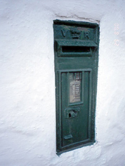 post box755 yd
 Man of WarHouse · 768 ydRing-ditch in SalmonRing-ditch · 937 ydFlat cemetery in BalcunninFlat cemetery · 1.2 miBbq AreaPicnic place · 1.7 miFlat cemetery in DarcystownFlat cemetery · 1.8 mi
.JPG/250px-Baldongan_Castle_(exterior).JPG "Photo: Cathalgibbons, Wikimedia Commons · CC BY-SA 4.0") Castle (in ruins)Castle, Anglo-Norman masonry castle · 1.9 mi
Castle (in ruins)Castle, Anglo-Norman masonry castle · 1.9 mi Ardgillan CastleHeritage attraction · 2.0 mi
 Balrothery Heritage CentreMuseum · 2.0 mi
 Balrothery TowerCastle · 2.0 mi
More archaeology and monuments in County Dublin · All of County Dublin
What do you know about this place?