Places near here
Photo credits
- DeeEmm, Geograph · CC BY-SA 2.0
- National Inventory of Architectural Heritage
- Mike Searle, Wikimedia Commons · CC BY-SA 2.0
- Malene Thyssen, Wikimedia Commons · CC BY-SA 3.0
- Superchilum, Wikimedia Commons · CC BY-SA 4.0
- Wanfried-Dublin, Wikimedia Commons · CC BY 4.0
- John M, Geograph · CC BY-SA 2.0
- Andreas F. Borchert, Wikimedia Commons · CC BY-SA 4.0
- Humphrey Bolton, Geograph · CC BY-SA 2.0
- Ian Capper, Geograph · CC BY-SA 2.0
 Castle in ruinsCastle, tower house · 1749 yd
Explorer Tom Castle in ruins in Caherglassaun is playing hide-and-seek with me. The local sheep think it's a very fancy rock, but I'm pretty sure one of them once held court there while wearing a hat. Give it a pat on the way past, it's had a long life.
 farm house1.1 mi
Explorer Tom Farm house in Loughcurra South would win the lotto and immediately buy a new roof because thatch is its nemesis. It stands perpendicular to the road like it’s daring you to cross the street without looking twice. That stout buttress isn’t for show, it’s pure structural ego.
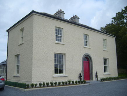 Maryville HouseHouse · 1.4 mi
Explorer Tom Maryville House has a priest who lost a bet there, and he’s still not over it. The limestone doorway is tooled so well it looks like it’s smiling at you. Spot the oldest stone and tell it a secret.
 Cahererillan CastleCastle · 1.8 mi
Explorer Tom Caher Castle has been in a bitter feud with the rain since about 1650, and neither of them is willing to admit that they actually need each other to survive. It’s standing there getting soaked and looking grumpy, probably plotting how to get back at the clouds for making its floors so slippery for the local cats to run on. Have a wander and a wonder.
 European Beech2.8 mi
Explorer Tom European Beech makes a sound at night that sounds exactly like someone trying to remember a song they heard as a child but can’t quite get right. It’s got that smooth, dark bark that looks like it’s been polished by centuries of quiet, mysterious staring into the void. Bring a flask of something warm and a story to swap.
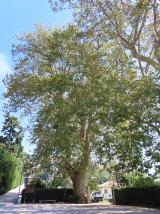 Oriental plane2.8 mi
Explorer Tom Oriental plane in County Galway refuses to fall down because it has an ego and thinks the ground is too messy for its roots. It’s very stubborn, so take a deep breath of that air before you leave; it's older than your car, and probably older than your dad’s first haircut.
Mulroney's IslandIslet · 3.4 miExplorer Tom Mulroney's Island is like that one relative at a wedding who stands by the buffet and judges your food choices silently. It doesn't dance, it doesn't mingle, it just watches you with mild suspicion from across the room. Bring wellies and low expectations, but leave feeling genuinely delighted somehow.
.jpg/250px-DoorusDemesne_(3).jpg "Photo: Wanfried-Dublin, Wikimedia Commons · CC BY 4.0") Wedge tomb in Doorus DemesneWedge tomb · 4.1 mi
Wedge tomb in Doorus DemesneWedge tomb · 4.1 miExplorer Tom Wedge tomb in Doorus Demesne has a chamber formed of uprights. It would buy a yacht with a lotto win and park it on the roof. Pick a stone, any stone, and invent its biography.
 Kilmacduagh Monastic SiteVisitor information · 4.6 mi
Explorer Tom Kilmacduagh Monastic Site thinks Dublin tourists are basically overgrown children who need a stern lecture about history and manners. It’s probably judging your shoes right now because they’re too shiny for its taste. It's free, it's odd, what more do you want?
 Templemore or Cathedral (in ruins)Cathedral · 4.7 mi
Explorer Tom Templemore or Cathedral in Kilmacduagh hears everything through its thick walls, including every bad joke told since the seventh century. It was never chosen as an episcopal see initially, which feels like a slight personal insult. Stand back, squint, and it looks like a castle.
 Kilmacduagh MonasteryHeritage attraction · 4.7 mi
Explorer Tom Kilmacduagh gives you a round tower and a name that has outlived several different churches. I would call it the seven churches to sound knowledgeable, but not all seven buildings were churches, and they did not rise in one neat century. Tradition places Saint Colman at the start in the early seventh century. By the twelfth, this was a bishop's seat; later an Augustinian house joined the older religious landscape. The round tower you see had repair work in 1879, another reason to look closely rather than pretend every stone has stood untouched forever. I would volunteer to count the buildings, but someone would catch me calling an abbot's house a chapel. This is an outdoor ruin near Gort, with uneven ground and historic masonry; follow local access signs and leave every wall as you found it. Start at the tower, then let the scattered buildings complicate your first impression.
 Traught BeachBeach / strand · 5.4 mi
Explorer Tom Traught Beach would teach history by starting with 'it was windy' and ending with 'and then we ate some fish,' skipping all the middle bits. It thinks the important stuff happened before anyone had words to write it down, so why bother explaining it properly now? A proper spot for a flask of tea and a big think.
More caves in County Galway · All of County Galway

What do you know about this place?Tap to add a comment or ask a question