
More pictures of this place


Places near here
Photo credits
- JP, Geograph · CC BY-SA 2.0
- National Inventory of Architectural Heritage
- Alvesgaspar, Wikimedia Commons · CC BY-SA 3.0
- Sitomon, Wikimedia Commons · CC BY-SA 2.0
- William Murphy from Dublin, Ireland, Wikimedia Commons · CC BY-SA 2.0
- AugusteBlanqui, Wikimedia Commons · CC BY-SA 4.0
- C O'Flanagan, Geograph · CC BY-SA 2.0
- VisionsofthePast, Wikimedia Commons · CC BY-SA 4.0
- Sudo77(new), Wikimedia Commons · CC BY-SA 4.0
 canal (section of)184 yd
 Maynooth Railway StationStation master's house · 197 yd
Explorer Tom Maynooth Railway Station Master’s House thinks the 1800s were just a time for red brick and no Wi-Fi. It would explain the steam era to a teen like it was a slow-loading app. Great spot
Memorial to 1916 Volunteers from MaynoothMemorial · 335 yd Common Lime450 ydThe Tree of Liberty 1798-1998Memorial · 450 yd
 European Yew508 yd
 Maynooth CastleHeritage attraction · 515 ydCastleCastle, Anglo-Norman masonry castle · 518 yd
Explorer Tom The Castle in Maynooth had a fox take charge of the kitchen once. Apparently, the rodents were terrified and very well fed that year. Hang around long enough and you'll hear a story from a local.
 National Science MuseumMuseum · 716 yd
 Moygaddy Tower HouseRuins · 1.1 mi
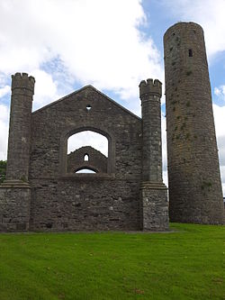 IndicatedEcclesiastical site · 2.0 mi
Explorer Tom Ecclesiastical site in Taghadoe was founded by Ultan the Silent, who clearly preferred not answering questions about Viking navigation errors. The tower is still there, but the silence is louder now. Bring a notebook and write the bit I made up.
 Round Tower2.0 mi
Explorer Tom Round Tower in Taghadoe is feuding with the next village over something daft, probably about who built the first wall. It’s roofless but still thinks it’s the tallest thing in town. Tell the next person you meet it's haunted. It might be.
More historic places in County Kildare · All of County Kildare

What do you know about this place?Tap to add a comment or ask a question