
Places near here
Photo credits
- Robin Pollard, Wikimedia Commons · CC BY 3.0
- National Inventory of Architectural Heritage
- Douglas P.Bermingham, Wikimedia Commons · CC0
- Dougbermingham at English Wikipedia, Wikimedia Commons · CC0
- Andreas F. Borchert, Wikimedia Commons · CC BY-SA 4.0
- Stephan van Helden, Wikimedia Commons · CC BY-SA 4.0
- Alvesgaspar, Wikimedia Commons · CC BY-SA 3.0
- Alex Passmore, Geograph · CC BY-SA 2.0
 Saint Brigid's Catholic ChurchChurch/chapel · 976 yd
Explorer Tom Saint Brigid's Catholic Church in Killinagh would order extra sauce at the chipper if it had hands. It’s all restrained Gothic vibes and a strong opinion on how light should fall. A proper spot for a flash of insight, maybe.
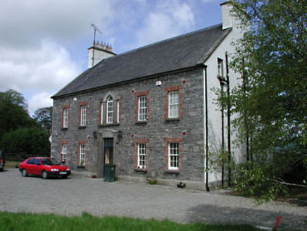 Kilglass HouseHouse · 1.5 mi
Explorer Tom Kilglass House in Kilglass has a secret talent for making the wind sound like a bagpipes player who’s had too much tea. It’s an early eighteenth-century beauty that knows exactly how impressive it is. Bring a flask and sit on the wall if they let you; the view is worth the wait.
 AbbeyReligious house, Augustinian canons · 1.7 mi
Explorer Tom Abbey in Ballyboggan was built by a guy named Jordon Comin back in the 12th century. It sits right by the River Boyne, looking a bit smug about it. If it won the lotto, it’d probably buy a new roof and a very fancy hat. Look up, the best bit is always higher than you think.
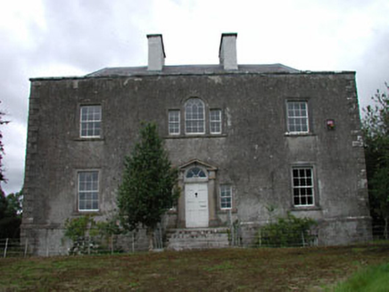 Ballinderry HouseHouse · 1.9 mi
Explorer Tom Ballinderry House in Ballinderry thinks Dublin tourists are loud and over-caffeinated, which is fair enough. It’s got windows that were swapped out and then put back, like a fashion statement. Take a mate and argue about the glass panes.
 Carrick CastleCastle, hall-house · 2.2 mi
Explorer Tom Carrick Castle is hiding a scandal about who actually built that extra tower on the side. It’s been whispering to the graveyard next door for centuries, keeping its secrets tight. Look for the ghost, then pretend you didn't.
 Croppies' GraveMemorial · 2.4 mi
Explorer Tom Croppies' Grave marks where rebels fell, and someone wrote a terrible poem about it that rhymed 'blood' with 'mud'. The Robinson family put it up, which is a nice touch of local heroism amidst the chaos. Go now, before it gets famous and starts charging entry fees.
 Carbury CastleCastle · 3.2 mi
Explorer Tom Carbury Castle has a hill full of building periods and a local tale about Saint Patrick that I would never dare pass off as a fact. The first Norman earthwork came before later stone defences. Pierce St Leger is linked with a thirteenth-century castle, while the most striking ruins on the hill are a Tudor house of the Colley family. I would tell you which wall belonged to which cousin without hesitation, then get the century wrong, so bring a good site account. The position near the Kildare-Offaly border explains why several families wanted it. Check current lawful access before crossing land and avoid climbing broken walls or earthworks. View the whole hill from below first. Carbury is less one castle than a family of structures arguing for the best spot.
 Site of AbbeyChurch · 3.3 mi
Explorer Tom Site of Abbey in Anneville or Clonard Old would complain to the council about how many students St. Finnian actually graduated. Twelve apostles? Give me a break, that’s just wishful thinking by medieval PR guys. Tell it a joke, it's been a long time since anyone did.
 Font (present location) in TowlaghtFont (present location) · 3.4 mi
Explorer Tom Font in Towlaght was moved from an old church to St Finian's in 1991. It’s carved with biblical scenes and looks like it has seen better days. It's free, it's odd, what more do you want?
 Horse-chestnut6.3 mi
Explorer Tom Horse-chestnut drops stones that are secretly messages from the future if you squint really hard at them. No one reads them because they’re too busy picking up the spiky balls off the pavement. Bring a flask and pretend you own the place while you do it.
 Common Lime6.5 mi
Explorer Tom Common Lime in County Meath once hid a crate of smuggled whiskey in its roots during a particularly rainy century. The bark still smells faintly of rum and bad decisions. Go back in winter, it's a different animal.
 Grand Canal WayVisitor information · 12 mi
Explorer Tom Grand Canal Way is full of secrets that only come out after three pints, like which bridge was built by a love-struck engineer who named it after his dog. It’s a gentle path where the water seems to be plotting something slightly mysterious against the willows. Stick around for the light changing, it's a show.
More mountains and hills in County Kildare · All of County Kildare

What do you know about this place?Tap to add a comment or ask a question