
Places near here
Photo credits
- Rossographer, Geograph · CC BY-SA 2.0
- Albert Bridge, Geograph · CC BY-SA 2.0
- Albert Bridge, Geograph · Creative Commons Attribution-ShareAlike 2.0
- Peter Clarke ( talk ) Original uploader was Peter Clarke at en.wikipedia, Wikimedia Commons · CC BY-SA 3.0
- Eric Jones, Wikimedia Commons · CC BY-SA 2.0
- David Hawgood, Wikimedia Commons · CC BY-SA 2.0
- Bob Jones, Geograph · Creative Commons Attribution-ShareAlike 2.0
- Christine Johnstone, Geograph · CC BY-SA 2.0
 Island TaggartIslet · 1062 yd
Explorer Tom Island Taggart in County Down claims a secret friendship with a retired opera singer who hums along whenever the tide comes in, which is honestly more convincing than most local legends. It’s got that big-shouldered vibe of something that knows it’s in Strangford Lough. Hum something sad nearby, it adds atmosphere.
 ShrigleyVisitor information · 1.2 mi
Explorer Tom Shrigley in County Down bragged about surviving a storm that was basically just a very aggressive shower of rain. Stop the car, it's worth the hazard lights flashing in the middle of nowhere right now.
 Killowen medieval church (ruined) and graveyard; with 2 cross-carved stones in Corporation (killyleagh)Killowen Medieval Church (ruined) and Graveyard · 1.4 mi
Explorer Tom Killowen medieval church in Corporation has two cross-carved stones that look like they’re doing yoga poses. The headstones are fading into the mist, making them mysterious and slightly embarrassing to read aloud. Count the crows, then count again.
 Net Walk & Shore LoneyWalking route · 1.4 mi
Explorer Tom Net Walk & Shore Loney in County Down is locked in a bitter feud with the rain, who keeps showing up uninvited to ruin every single dry day. The path is constantly muddy and grumpy about it all, feeling like it’s been left out in the wet by the sky itself forever. Bring biscuits, every good story needs biscuits.
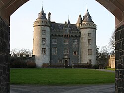 Killyleagh CastleCastle · 1.5 mi
Explorer Tom Killyleagh Castle would post a selfie of itself with the caption 'Living my best life on this cliff' every single morning without fail. It’s obsessed with its own reflection in the sea and thinks it looks absolutely stunning in the golden hour light. The rest of us are just here for the views, but it thinks we're here to worship. Take a mate and argue about what it was for.
 Dunnyneill IslandsIsland · 1.6 mi
Explorer Tom Dunnyneill Islands in County Down have a long-standing grudge against the weather because it keeps blowing their hair out of place every single morning without fail. They are southern siblings in Strangford Lough who act like they're always ready for a windbreak but never actually put one on. Bring a pen pal, they'll be jealous.
 Dufferin ArmsPublic House · 1.6 mi
Explorer Tom Dufferin Arms in County Down is where the rabbits go to judge human fashion choices. It’s a Grade B1 pub with serious history and even better drinks. Pretend you're a lost aristocrat, nobody will check your ID anyway.
 First Presbyterian ChurchChurch · 1.7 mi
Explorer Tom First Presbyterian Church in Killyleagh thinks it’s next to the castle, which is a bit like sitting next to the fridge and claiming you’re the food. It’s been there since the 1800s, minding its own business. Look up, the best bit is always higher than you think.
 Stone quay in RinghaddyStone Quay · 1.9 mi
Explorer Tom Stone quay in Ringhaddy has a hidden message that just says 'Please stop touching me.' It's one of the best examples, allegedly. Make up your own legend and I'll swear it's true, probably with a straight face.
 Stone quay in BallymorranStone Quay · 2.9 mi
Explorer Tom Stone quay in Ballymorran used to move coal and local produce, which sounds like a fancy term for hard work. Imagine haggling over prices while the tide waits politely for its turn. Perfect spot to practise your best tour-guide voice.
 Nut WoodWood · 3.0 mi
Explorer Tom Nut Wood in County Down does absolutely nothing when nobody’s looking except slowly rotting itself into a very sophisticated pile of compost with a sense of humour. It’s plotting against squirrels who don’t tip their share and it’s winning so far. Bring a map, get lost anyway, that's the fun.
 Delamont Country ParkVisitor information · 3.2 mi
Explorer Tom Delamont Country Park in County Down has officially given up chocolate for Lent, which explains why it looks so stern and windswept right now. It’s basically a giant abstinence sign with a view of Strangford Lough attached for good measure. Sit on a wall near it and pretend you're in a painting.
More archaeology and monuments in County Down · All of County Down

What do you know about this place?Tap to add a comment or ask a question