
What is recorded here
Current recorded use: Church.
From the Northern Ireland Historic Buildings Record record HB18/03/022
The official record and map point do not grant access. Many historic buildings are privately owned; view them only from public ground unless the owner allows entry.
Places near here
 Dufferin ArmsPublic House · 216 yd
 Second Killyleagh Presbyterian ChurchChurch · 246 yd
 Killyleagh CastleKillyleagh castle, multiperiod castle on site of Motte · 288 yd
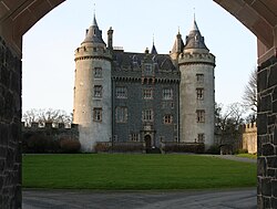 Killyleagh CastleCastle · 297 yd
 Killowen medieval church (ruined) and graveyard; with 2 cross-carved stones in Corporation (killyleagh)Killowen Medieval Church (ruined) and Graveyard · 583 yd
 Net Walk & Shore LoneyWalking route · 910 yd
 ShrigleyVisitor information · 1319 yd
 Green IslandIslet · 1.3 mi
 Nut WoodWood · 1.3 mi
 Island TaggartIslet · 1.4 mi
 Kinneagar WoodWood · 1.5 mi
 Delamont Country ParkVisitor information · 1.5 mi
Pictures: Eric Jones, Wikimedia Commons · CC BY-SA 2.0; Shane Killen, Geograph · CC BY-SA 2.0; Peter Clarke ( talk ) Original uploader was Peter Clarke at en.wikipedia, Wikimedia Commons · CC BY-SA 3.0; Albert Bridge, Geograph · Creative Commons Attribution-ShareAlike 2.0; Albert Bridge, Geograph · CC BY-SA 2.0; Rossographer, Geograph · CC BY-SA 2.0; Christine Johnstone, Geograph · CC BY-SA 2.0
More historic places in County Down · All of County Down
What do you know about this place?