What is recorded here
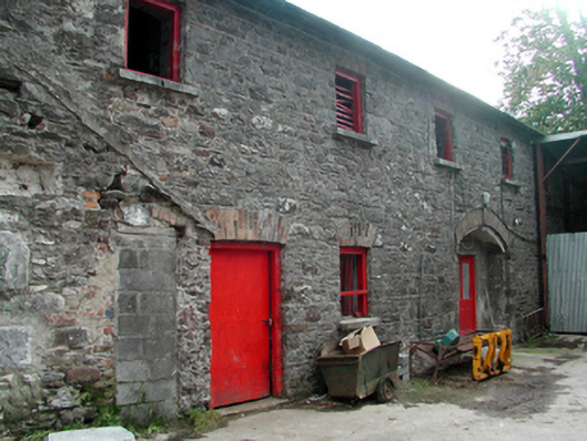
Detached four-bay single-storey rubble stone outbuilding, c.1840, on an L-shaped plan with segmental-headed carriageway to right ground floor, originally with single-bay single-storey gabled projecting end bay to left ground floor, and two-bay two-storey lower return to south-east. Renovated, c.1965, with carriageway remodelled, and projecting end bay removed. Pitched slate roofs with clay ridge tiles, and cast-iron rainwater goods on slightly overhanging eaves. Random rubble stone walls with lime mortar. Square-headed window openings with cut-stone sills, red brick ‘voussoirs’, and louvered timber panel fittings. Square-headed door openings (including to first floor to return) with red brick ‘voussoirs’ to main block, squared rubble stone voussoirs to return, and replacement iron-sheeted doors, c.1965. Segmental-headed carriageway remodelled, c.1965, to accommodate square-headed door opening with red brick ‘voussoirs’, and replacement glazed timber panelled door, c.1965. Set back from road in grounds originally shared with Mount Rivers (House) with house demolished, c.1990.
A well-composed middle-size outbuilding retaining much of its original form and fabric. The construction in rubble stone with red brick dressings produces an attractive textured and slightly polychromatic visual effect, which enhances the appeal of the composition. The outbuilding is of particular importance as a reminder of the extent of the Mount Rivers (House) estate, the house having been demolished.
From the Buildings of Ireland (National Inventory of Architectural Heritage) record 22902920
This does not grant access. Most recorded buildings are privately owned; view them only from public ground unless the owner allows entry.
Places near here
Photo credits
- MonikaLisa2, Wikimedia Commons · CC BY-SA 4.0
- Colin Park, Wikimedia Commons · CC BY-SA 2.0
- Liam Hughes, Wikimedia Commons · CC BY 2.0
- TheLizardQueen, Wikimedia Commons · CC BY 2.0
- Mike Searle, Wikimedia Commons · CC BY-SA 2.0
- Taken by Fanghong, Wikimedia Commons · CC BY-SA 3.0
- Miguel Angel Masegosa Martínez, Wikimedia Commons · CC BY 2.0
- Mac McCarron, Geograph · CC BY-SA 2.0
- Andreas F. Borchert, Wikimedia Commons · CC BY-SA 4.0
- N Chadwick, Geograph · Creative Commons Attribution-ShareAlike 2.0
- Jonathan Thacker, Geograph · CC BY-SA 2.0
- Haydn.hammerton, Wikimedia Commons · CC BY-SA 4.0
 Affane ChurchChurch/chapel · 619 yd
 Dromana HouseGate lodge · 649 yd
 Dromana GateHeritage attraction · 649 yd
 Battle of AffaneMajor battlefield · 686 yd
 Tourin CastleCastle, tower house · 1580 yd
 London Plane1694 yd
 Sweet Chestnut1.3 mi
 Lady Louisa's WalkWalking route · 3.6 mi
 Cathedral3.7 mi
 St. Carthaghs WellHoly well · 3.8 mi
 Ambrose Power MemorialMemorial · 3.8 mi
 Lismore CastleGates/railings/walls · 3.8 mi
More historic places in County Waterford · All of County Waterford
What do you know about this place?