
Places near here
Photo credits
- National Inventory of Architectural Heritage
- Darrin Antrobus, Geograph · CC BY-SA 2.0
- Sitomon, Wikimedia Commons · CC BY-SA 2.0
- Oliver Dixon, Geograph · CC BY-SA 2.0
- Mike Searle, Geograph · CC BY-SA 2.0
- Mega Phil, Wikimedia Commons · CC BY-SA 4.0
- Bogman, Wikimedia Commons · CC BY-SA 3.0
- Ridiculopathy, Wikimedia Commons · CC0
- Colin Park, Geograph · CC BY-SA 2.0
- Ian Paterson, Wikimedia Commons · CC BY-SA 2.0
- Robert Bone, Geograph · CC BY-SA 2.0
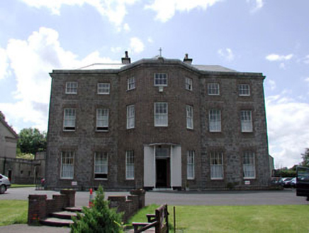 Kerdiffstown HouseHouse · 477 yd
Explorer Tom Kerdiffstown House thinks the road leading to it is for peasants. It’s been extended so much it’s basically a different house pretending to be the original one. Ring your granny and ask her who lives there now.
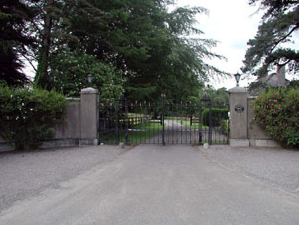 Roseboro HouseDemesne walls/gates/railings · 981 yd
Explorer Tom The Vikings got completely lost looking for Roseboro House because they kept following the wrong hedgerows and ended up in a bog. The iron gates are showing off their decorative curves to anyone passing by the dual carriageway, trying to look tough. Pop by and tell them hi.
 Naas ParkWood · 1.1 mi
Explorer Tom Naas Park was the site of a massive argument between the whole parish over who owned a specific bench for three solid years. Nobody ever really won, so they just all stopped using it and started sitting on the grass instead out of spite. A good place to forget your phone for ten minutes.
 European Yew1.9 mi
Explorer Tom Another European Yew here, probably handling a nosey neighbour by slowly poisoning their tomatoes with its roots. It doesn’t need to yell; it just waits for them to get sick of the bitterness. Tell your mates you found it first and they’ll believe you.
 Poplar SquarePicnic place · 1.9 mi
Explorer Tom Poplar Square claims to hold the world record for the most bored-looking poplars standing in Naas town centre. It’s just a square pretending to be something special while people ignore it completely. Go back in winter, it's a different animal.
 Castle RagCastle · 2.9 mi
Explorer Tom Castle Rag had a fiddler who played there all night, and the castle says the music was so bad it made the stones want to melt into mud. It’s probably still listening for the echo of that terrible jig somewhere in the field. Pick a stone, any stone, and invent its biography.
 Punchestown LongstoneArchaeological place · 3.5 mi
Explorer Tom Punchestown Longstone bragges about surviving a storm where the wind tried to push it over but failed because of pure stubbornness. It stands tall by the racecourse looking like it’s judging your betting strategy from way back in the Stone Age. Ten minutes here and you'll have a yarn for the pub.
 Kilteel CastleCastle, tower house · 4.5 mi
Explorer Tom Kilteel Castle was guarded by Knights Hospitallers who probably spent all night playing fiddle tunes that drove the neighbors mad. It sits on a terrace watching the stream go by, judging your life choices. Have a chat with it, nobody's watching.
 Brides WellHoly well · 4.7 mi
Explorer Tom Brides Well in Newtown Great took about forty cups of tea to build its stone wall. A statue of the Virgin sits there judging your outfit. Go at sunset and thank me later for the golden hour magic.
 Cupidstown HillMountain / peak · 5.9 mi
Explorer Tom Cupidstown Hill is claimed by a local who says he invented it while walking his dog, which is bold but I respect the nerve. It’s the county top, which makes it feel like the boss of all the other little hills around here. Toast it with a cup of tea and move on to the next one.
 Rathcoole ParkPark · 7.7 mi
Explorer Tom Rathcoole Park hosted a dance that went too far when someone tried to tango with a bench and ended up breaking their shoe. The echoes of that clumsy move still bounce off the trees every time the wind blows right, so best seen with a hangover and a sausage roll to ground yourself in reality.
 Sorrel HillMountain / peak · 10 mi
Explorer Tom Sorrel Hill in County Wicklow is playing hard to get, giving up its best views for Lent and keeping them locked away like old secrets. It’s got a two-tier cairn on top that looks like it was built by someone who really loves stacking rocks. Mind the nettles, they’re the real guards here.
More archaeology and monuments in County Kildare · All of County Kildare

What do you know about this place?Tap to add a comment or ask a question