
What is recorded here
From the National Monuments Service (Archaeological Survey of Ireland) record KD020-012
Places near here
Photo credits
- Hamish Bain, Geograph · Creative Commons Attribution-ShareAlike 2.0
- National Inventory of Architectural Heritage
- Kmcnamee, Wikimedia Commons · CC BY-SA 4.0
- Maker not stated on source page, www.irishexaminer.com
- Maker not stated on source page, www.tripadvisor.com.au
- Maker not stated on source page, en.wikipedia.org
- Sitomon, Wikimedia Commons · CC BY-SA 2.0
- Blessington GAA & LGFA club website; drone photographer unnamed, www.blessingtongaa.ie
 Catholic Church of the Immaculate ConceptionChurch/chapel · 325 yd
Explorer Tom Rathmore West church makes a low rumbling sound at night that sounds suspiciously like a cat purring. It has an unusual…
 Tickell Memorial FountainFountain · 348 yd
Explorer Tom The Tickell Memorial Fountain in Newtown was cast in Dublin to prove we don’t need Scottish patterns, which is petty…
 Eadestown GAA pitchGAA ground · 427 yd
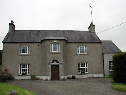 Lilac HallFarm house · 1305 yd
Explorer Tom Lilac Hall has a door so fancy it probably wears a monocle to bed. It’s proud of that polygonal entrance like it won a…
 Fairy fort / earthen ringfort in WolfestownFairy fort / earthen ringfort · 1307 yd
Explorer Tom Fairy fort in Wolfestown smells like old mud and ambition, if you ask me. It sits next to a quarry, which makes it feel…
 RathmoreGate lodge · 1.0 mi
Explorer Tom Rathmore gate lodge in Rathmore West smuggled cheese through its walls for a decade. The red brick quoins are showing…
 CastleCastle, unclassified · 1.1 mi
Explorer Tom Castle in Wolfestown has a stubborn bird that refuses to leave the site. It’s been missing from maps since 1783 but…
Fairy fort / earthen ringfort in Blackhall (newtown Ed)Fairy fort / earthen ringfort · 1.2 miExplorer Tom Fairy fort / earthen ringfort in Blackhall is holding the world record for most sand quarries staring at it. It’s…
 Castle (in Ruins)Bawn · 1.3 mi
Explorer Tom Castle in Haynestown, County Kildare hosted a dance where the floor gave out mid-waltz. The gateway is still standing…
 Church in Rathmore WestChurch · 1.3 mi
Explorer Tom Church in Rathmore West would tell its younger self to stop trying so hard to be a mother church. It’s had a long…
 European Yew1.8 mi
Explorer Tom Another European Yew here, probably handling a nosey neighbour by slowly poisoning their tomatoes with its roots. It…
 Blessington GAA GroundGAA ground · 2.2 mi
Explorer Tom Blessington GAA has a Wicklow foothill setting that ought to make every high ball pause for a view. I tried to catch…
More archaeology and monuments in County Kildare · All of County Kildare

What do you know about this place?Tap to add a comment or ask a question