
What is recorded here
Situated on a low N-S ridge in flat pasture with the Derheen River 40m to the E. Depicted as a trapezoidal-shaped enclosure on the 1903 ed. OS 6-inch map. During a recent archaeological assessment carried out in November of 2010 under excavation licence number 10E448, the cropmark of the levelled monument was visible…
Read the whole record
From the National Monuments Service (Archaeological Survey of Ireland) record TN042-054
Places near here
Photo credits
- Wanfried-Dublin, Wikimedia Commons · CC BY-SA 3.0
- A.-K. D., Wikimedia Commons · CC BY-SA 4.0
- National Inventory of Architectural Heritage
- Maker not stated on source page, commons.wikimedia.org
- Maker not stated on source page, www.pinterest.com
- Maker not stated on source page, www.ireland.com
- Maker not stated on source page, irishheritagenews.ie
- Maker not stated on source page, en.wikipedia.org
 Ecclesiastical site in LeighEcclesiastical site · 1188 yd
Explorer Tom Ecclesiastical site in Leigh is guarding a legend about a giant who got stuck in the bog and never quite left. St…
 Leighmore Church (in ruins)Church · 1227 yd
Explorer Tom Leighmore Church in Leigh, County Tipperary, would handle a nosey neighbour by simply being too small to see clearly…
 Sheela-na-gig in LeighSheela-na-gig · 1230 yd
Explorer Tom Sheela-na-gig in Leigh is lying sideways on a church doorway, looking like she’s having a very long lunch and doesn’t…
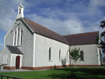 Saint James's Catholic ChurchChurch/chapel · 1.2 mi
Explorer Tom Saint James's Catholic Church is being picked on by the wind because it refuses to wear a hat or anything to keep its…
 CastleCastle, ringwork · 1.2 mi
Explorer Tom Castle in Borris has strong opinions on modern architecture, mostly because there isn’t much left to complain about.…
 Two Mile Borris CemeteryCemetery · 1.3 mi
Explorer Tom Two Mile Borris Cemetery in County Tipperary would explain the 1800s to a teenager as the era before everyone stopped…
 Church (in ruins)Graveyard · 1.3 mi
Explorer Tom Church in Borris has a superstition that says touching the wall guarantees good luck at football. It’s just a short…
 Fairy fort / earthen ringfort in Ballybeg (two-Mile-Borris Par.)Fairy fort / earthen ringfort · 2.4 mi
Explorer Tom Fairy fort / earthen ringfort in Ballybeg has been busy smuggling contraband cheese since 1800, which explains why its…
 Fairy fort / earthen ringfort in Coldfields,rathmanna (twomileborris Par.)Fairy fort / earthen ringfort · 3.1 mi
Explorer Tom Fairy fort / earthen ringfort in Coldfields, Rathmanna hates when people trip over its grassy ditches because they’re…
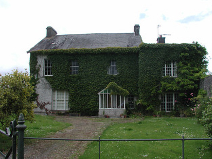 Archerstown HouseCountry house · 3.9 mi
Explorer Tom Archerstown House in Archerstown has windows that couldn't agree on a direction, which is honestly very modern for a…
 Moycarky CastleCastle, tower house · 5.1 mi
Explorer Tom Moycarky Castle has strong opinions about the road leading to it and thinks it needs more potholes for character and…
 St. Peter's New CemeteryCemetery · 5.3 mi
Explorer Tom St. Peter's New Cemetery claims a fiddler played here all night until dawn broke his heart. The music supposedly still…
More archaeology and monuments in County Tipperary · All of County Tipperary

What do you know about this place?Tap to add a comment or ask a question