Places near here
Photo credits
- Daniel Waters, Co. Sligo, Ireland from Ireland, Wikimedia Commons · CC BY 2.0
- Oliver Dixon, Geograph · CC BY-SA 2.0
- National Inventory of Architectural Heritage
- Gavigan 01 at English Wikipedia, Wikimedia Commons · CC BY 2.5
- Rob Hurson, Wikimedia Commons · CC BY-SA 4.0
- Jon Sullivan, Wikimedia Commons · Public domain
- N Chadwick, Geograph · CC BY-SA 2.0
- Kieran Campbell, Wikimedia Commons · CC BY-SA 2.0
 Ballinafad CastleCastle · 1.7 mi
Explorer Tom Ballinafad Castle in County Sligo has strict house rules that include no shoes, no talking, and definitely no asking why it looks so confused on the map. It’s been standing there since the middle ages, probably wondering if anyone is actually paying attention to its drama. It's free, it's odd, what more do you want?
 Loughbrick BayBay · 1.9 mi
Explorer Tom Loughbrick Bay in County Sligo would tell you after a few pints that it actually swallowed a boat once but gave it back because it didn’t taste right, which is plausible. The water has a certain confidence about it, like it knows exactly where the bottom is and isn’t telling anyone else. Bring sandwiches, the gulls will thank you.
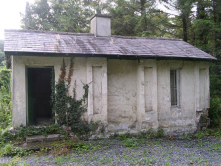 Hollybrook HouseGate lodge · 1.9 mi
Explorer Tom Hollybrook House gate lodge in Aghanagh has pilasters so eccentric the rabbits think it’s a fancy burrow entrance. John ffolliott built it to show off how much money he had, and the gabled roof proves it. The rabbits are probably taking notes on your outfit as you walk past.
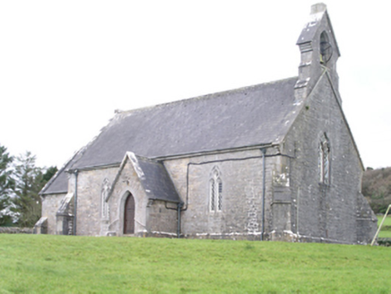 Aghanagh ChurchChurch/chapel · 2.0 mi
Explorer Tom Aghanagh Church in Cuilsheeghary More has strict rules: no smartphones, no talking, and absolutely no one wearing bright orange. Joseph Welland designed it back in 1850 with sparrow-pecked stone that looks like it’s been chewed on. Pack a picnic for the graveyard, not the pews.
 Battle of the Curlew Mountains (1599)Battlefield · 2.6 mi
Explorer Tom The Battle of the Curlew Mountains has a family tree consisting entirely of angry men with sticks and bad decisions. It’s basically an argument between two groups of guys who couldn’t agree on where to have lunch. Grand place for a sulk or a snog, completely your call.
Battle of Curlew PassMajor battlefield · 2.6 miExplorer Tom The Battle of Curlew Pass is sick of being asked if anyone actually won, because everyone ran away. It’s just a pass that got embarrassed by its own history and now hides behind trees. Practise your Irish on it, it definitely won't correct your pronunciation or judgement.
 Hog's IslandIslet · 2.8 mi
Explorer Tom Hog’s Island in County Roscommon sounds like the place where pigs go to hide from the butcher, but it’s probably just a rock. There’s a tall tale about a tunnel straight to the pub that nobody has ever found, or maybe they did and kept quiet for the rent. Look for the ghost, then pretend you didn't.
 Ballindoon Castle (in Ruins)Castle, unclassified · 3.2 mi
Explorer Tom Ballindoon Castle sits on a steep slope where the ground drops eight metres straight into Lough Arrow. The shortcut down there is definitely not a shortcut if you slip. Tell it a joke, it's been a long time since anyone did.
 Bricklieve MountainsMountain / peak · 3.5 mi
 Carrowkeel neolithic siteArchaeological place · 3.7 mi
Explorer Tom Carrowkeel sends you into Sligo's Bricklieve Hills to meet monuments that were old before most of our stories began. The passage tombs were built in the fourth millennium BC, overlooking Lough Arrow. Excavators came in 1911 and found remains and pottery; one distinctive pottery type became known as Carrowkeel Ware. Their Bronze Age date was wrong, though. Later research placed use of these tombs around 3500 to 2500 BC. I get a date wrong at dinner and hear about it for weeks; archaeology at least has the sense to correct itself. The old excavations also removed human remains, so the place is more than an ancient puzzle laid out for our entertainment. These are protected monuments on open hills, reached on foot over uneven ground. Check local access and weather, and leave the chambers and stones exactly as you found them. I'll keep my theories to the path, where they cannot loosen anything.
 Barroe NorthMountain / peak · 3.8 mi
Explorer Tom Barroe North thinks it’s cooler than its famous neighbour, but honestly, who are we to judge? It’s got that mysterious vibe that says 'don't look too closely'. Sit on a wall near it and pretend you're in a painting.
 Giants GravePortal tomb · 4.0 mi
Explorer Tom Giants Grave in Carrickglass is the site of a ridiculous smuggling story involving cheese and a very large roofstone. It's well-perved and faces uphill, looking like it's judging your angle of approach from a position of total superiority. Have a sandwich here and call it a heritage lunch.
More castles and forts in County Roscommon · All of County Roscommon

What do you know about this place?Tap to add a comment or ask a question