DDiscover AloneMapAbout

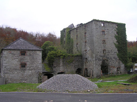
Mill in Ennisnag

Mill (water)
Mill in Ennisnag
Photo: National Inventory of Architectural Heritage · Report the wrong picture

This does not grant access. Most recorded buildings are privately owned; view them only from public ground unless the owner allows entry.

What do you know about this place?Tap to add a comment or ask a question

What you write will be public.

What is recorded here

Flour mill complex, c.1800, including:(i) Detached three-bay five-storey rubble stone flour mill with single-bay six-storey end bay to left, single-bay five-storey return to west, and two-bay double-height projecting block to ground floor continuing into two-bay single-storey mono-pitched linking range having pair of…

Read the whole record
Flour mill complex, c.1800, including:(i) Detached three-bay five-storey rubble stone flour mill with single-bay six-storey end bay to left, single-bay five-storey return to west, and two-bay double-height projecting block to ground floor continuing into two-bay single-storey mono-pitched linking range having pair of elliptical-headed carriageways. Subsequently in use as corn mill, pre-1948. Disused, 1948. Now in ruins. Hipped slate roofs (now missing from main portion and partly collapsed to end bay; pitched roof to projecting block now gone; mono-pitched roof to connecting range) with clay ridge tiles, and no rainwater goods surviving on squared rubble stone eaves. Irregular coursed squared rubble stone walls with dressed limestone quoins to corners, and remains of unpainted render to end bay. Square-headed window openings in camber-headed recesses with no sills, red brick dressings including voussoirs, and some remains of timber fittings. Pair of elliptical-headed carriageways to connecting range on cut-limestone pier with squared limestone voussoirs, and no fittings. Set back from road in own grounds with rubble grounds to site.(ii) Attached three-bay two-storey outbuilding, c.1800, to north-east with elliptical-headed carriageway to ground floor, and single-bay three-storey side elevations. Refenestrated, c.1975. Now disused. Hipped slate roof with clay ridge tiles, and no rainwater goods on squared rubble limestone eaves. Random rubble stone walls with dressed limestone quoins to corners. Square-headed window openings in camber-headed recesses with no sills, red brick block-and-start surrounds, and replacement timber casement windows, c.1975, having one replacement aluminium casement window, c.1975, to ground floor. Camber-headed door opening with red brick block-and-start surround, and replacement diagonal tongue-and-groove timber panelled door, c.1975. Elliptical-headed carriageway to ground floor with red brick voussoirs, and replacement diagonal tongue-and-groove timber panelled double doors, c.1975.
A cluster of rubble stone buildings representing an important artefact of the industrial heritage of Stoneyford having historically supported much of the local agricultural economy from the late eighteenth or early nineteenth century. Exhibiting a foreboding quality on account of attributes identifying the architectural design value of the composition including the verticality of the massing, the regular pattern of the arrangement of small-scale openings, and so on the mill forms an imposing landmark in the locality. Having fallen into the early stages of ruination following a prolonged period out of use the complex survives as an appealing feature of some Romantic quality in a rural landscape that appears to be reclaiming the site.

From the Buildings of Ireland (National Inventory of Architectural Heritage) record 12316004

Places near here

Photo credits
  • A.-K. D., Wikimedia Commons · CC BY-SA 4.0
  • Maker not stated on source page, www.flickr.com
  • National Inventory of Architectural Heritage
  • Maker not stated on source page, www.pinterest.com
  • Maker not stated on source page, directmap.irish
  • Maker not stated on source page, in.pinterest.com
bridge243 yd

Explorer Tom Bridge in Cotterellsbooly has a hidden message carved into its stones that translates roughly to ‘don’t touch my rocks’…

Bridge in Ennisnag,cotterellsbooly,lawcusBridge · 363 yd

Explorer Tom Bridge in Ennisnag, Cotterellsbooly, Lawcus is having a midlife crisis. It crossed that river back in 1655 and still…

Ennisnag BridgeBridge · 484 yd

Explorer Tom Ennisnag Bridge in Cotterellsbooly is doing its best to look elegant while you cross it. Legend says a dance once got…

Saint Peter's Church (Ennisnag)Church/chapel · 576 yd

Explorer Tom Saint Peter's Church in Ennisnag is built right next to a corn mill, so the locals swear if you tie your horse wrong…

Ennisnag GraveyardGraveyard · 576 yd

Explorer Tom Ennisnag Graveyard is stuck on a New Year's resolution to stop complaining about its backache, but honestly, it’s…

TobermogueHoly well · 582 yd

Explorer Tom Tobermogue is covered over and looks like it’s taking a permanent nap by the roadside. There’s a bird that refuses to…

Church in EnnisnagChurch · 585 yd

Explorer Tom Church in Ennisnag has a secret talent for being demolished to build something better next door. It was taken down…

lamp standard769 yd

Explorer Tom Lamp standard in Cotterellsbooly sings 'Twinkle Twinkle Little Star' but gets the key wrong every time. It's an early…
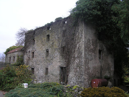
Ennisnag HouseMill (water) · 786 yd

Explorer Tom Ennisnag House water mill does weird things when nobody’s looking, like pretending it’s still grinding flour from 1800.…
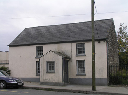
Historic building in CotterellsboolyUnknown · 832 yd

Explorer Tom Cotterellsbooly’s mysterious building wants its tombstone to say 'Probably a school, possibly just a very confused…

Saint Brendan's Church CemeteryGraveyard · 871 yd

Explorer Tom Saint Brendan's Church Cemetery saw a goat once attempt to eat the vicar’s hat during a service, which caused absolute…

Fairy fort / ringfort in EnnisnagFairy fort / ringfort · 1315 yd

Explorer Tom Fairy fort / ringfort in Ennisnag is oval because round was too boring for the faeries. The seagulls say it looks like…

More historic places in County Kilkenny · All of County Kilkenny

Add to this placeAdd a picture Add a detailed tip Add a story

Explore the map1,095,414 places to discover

Next place · or swipebridge