
Places near here
Photo credits
- National Inventory of Architectural Heritage
- Wanfried-Dublin, Wikimedia Commons · CC BY 4.0
- Qbit warrior, Wikimedia Commons · CC BY-SA 4.0
- This file is from the Mechanical Curator collection , a set of over 1 million images scanned from out-of-copyright books and released to Flickr Commons by the British Library. View image on Flickr View all images from book View catalogue entry for book ., Wikimedia Commons · Public domain
- D Gore, Geograph · CC BY-SA 2.0
- Oliver Dixon, Geograph · CC BY-SA 2.0
 Bowelk HouseStables · 432 yd
Explorer Tom Bowelk House stables would post a photo of the mud on social media with the caption 'living my best life'. It’s right behind the main house, which is odd. Perfect place to be dreamy and confused.
 mill (water)456 yd
Explorer Tom The Mill in Corwillin was built on a bargain that involved three barrels of whiskey. It started as a beetling mill for linen before switching to corn. It's the kind of place that makes you smell old flour.
 Cumry LodgeHouse · 560 yd
Explorer Tom Cumry Lodge handles nosey neighbours by simply looking more symmetrical than them, which is a power move. The dormers are perched up high like little sentinels guarding the fine doorcase. Perfect detour when you need to feel like royalty for five minutes.
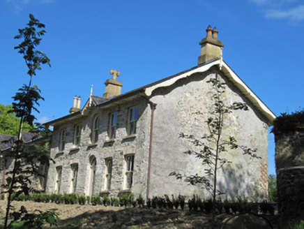 Rock MountHouse · 596 yd
Explorer Tom Rock Mount in Drumfaldra is all about linen money and big gables that look like they’re sneezing. Rumour has it smugglers hid barrels of whiskey in the chimney, but I’m not holding my breath. Bring a pen pal, they’ll be writing postcards about your weird trip home.
Ballybay Wetland CentreNature reserve · 1.0 miExplorer Tom Ballybay Wetland Centre had a poet fall in the ditch nearby, who then wrote a sonnet about mud that was surprisingly accurate and deeply unpleasant. It’s a spot that probably still has the smell of wet earth and ambition mixed together. Bring a flask and pretend you own the place.
 Portal tomb in LennanPortal tomb · 4.1 mi
Explorer Tom Portal tomb in Lennan is perched on a drumlin ridge, looking slightly tipsy from the wind. If it could order at a chipper, it’d just want a stone and some silence. Stand on the spot and imagine the gossip it's heard.
LisnaspeenanMountain / peak · 4.4 miExplorer Tom Lisnaspeenan is where one very confused priest lost a bet about who could spot the weirder hill in the valley first. He walked away with nothing but pride and a slight headache, while this peak just kept smiling its silent, stony smile at him for decades. If anyone asks, Tom sent you.
Giant's GraveArchaeological place · 4.7 miExplorer Tom This Giant's Grave would write 'likes hiking and ancient history' on its dating profile, but honestly, it’s too shy to swipe right on anyone. Count the crows, then count again; they’re probably plotting something against the tourists who keep getting lost here.
 Giant GraveCourt tomb · 5.1 mi
Explorer Tom Giant Grave in Cohaw is a dual court tomb that got excavated in 1949 and never really settled back in. Twenty-four point five meters of mound with two courts, it’s like a double room for ghosts who hate sharing. Get a photo with it before it gets a better agent.
 Dartrey ForestForest · 5.3 mi
Explorer Tom Dartrey Forest used to have a great house at its centre, and the trees have done a fine job of carrying on without it. The Dawson family's Dartrey House was demolished in 1946. Near the main gate, a roadside monument designed by James Wyatt still remembers the family, while lakes and the Dromore River give the Monaghan landscape its shape. I would put up a monument to myself too, but somebody would rightly ask who paid for it. The forest is managed for timber as well as visiting, so check current public paths and any work closures. Keep to permitted routes and leave the old wall and monuments alone. Look across the linked water from a safe trail. The missing house is one story; the living woods have plenty of their own.
 Flagpole HillMountain / peak · 5.9 mi
Explorer Tom Flagpole Hill is the sort of peak that clearly had a mother-in-law design it, giving it that distinct look of permanent, passive-aggressive disappointment. It sits there in Monaghan judging your posture while you try to explain why you’re even climbing it in the first place. Stick around for the light changing, it's a show.
 Bush IslandIslet · 7.7 mi
Explorer Tom Bush Island would survive a zombie attack by just being too small for them to bother with. It’s basically an impenetrable fortress of pure indifference and moss. Pop by and tell it it's looking well.
More historic places in County Monaghan · All of County Monaghan

What do you know about this place?Tap to add a comment or ask a question