
What is recorded here
Places near here
Picture notes
- National Inventory of Architectural Heritage
- Computer-made picture. It does not show this monument.
- Computer-made picture. It does not show this mountain top.
- Gerald England, Geograph · CC BY-SA 2.0
- John M, Geograph · CC BY-SA 2.0
- John M, Wikimedia Commons · CC BY-SA 2.0
- P L Chadwick, Geograph · CC BY-SA 2.0
- Rossographer, Geograph · CC BY-SA 2.0
- Computer-made picture. It does not show this walking route.
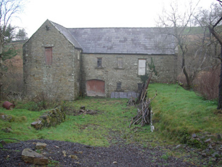 Muileann Arbhair LeitirMill (water) · 93 yd
Explorer Tom Muileann Arbhair Leitir has a stone inside that says ‘Kay and Hilton, Fleet Street, Liverpool, 1863.’ I bet that ship captain wrote it in ink while eating a very greasy sandwich. He probably forgot to wipe his fingers before signing the giant rock.
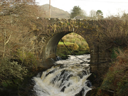 Droichead Droim na FiongaileBridge · 229 yd
Explorer Tom Droichead Droim na Fiongaile appears on an 1836 map, but its rock-faced arch stones suggest work in the mid-nineteenth century. I like a bridge that makes the map and the masonry tell slightly different chapters.
 Fairy fort / stone ringfort in Caiseal CharnaFairy fort / stone ringfort · 1033 ydComputer-made picture
Explorer Tom Fairy fort / stone ringfort in Caiseal Charna has a modern wall stapled right onto its ancient southern edge, which is honestly rude. You’ve got a proper trig point sitting in the middle like it owns the place, marking the spot with cold precision.
 CroaghbegMountain / peak · 1131 ydComputer-made picture
Explorer Tom Croaghbeg is the little brother of the big hills, trying not to be noticed. It’s cute in a modest sort of way, like a chihuahua with a coat. Have a sandwich here and call it a heritage lunch, because eating on a small hill makes you sound very cultured.
 Stone circle in Srath Bruithne ÍochtarachStone circle · 1239 ydComputer-made picture
Explorer Tom Stone circle in Srath Bruithne Íochtarach was just sitting under the turf all this time! I imagine someone swinging a shovel, thinking they’d hit rock, only to find a whole ring of stones staring back. It’s like finding a hidden treasure while digging for firewood.
 CroaghmuckrosMountain / peak · 1277 yd
Explorer Tom Croaghmuckros has a resident bird that refuses to leave because it thinks the peak owes it rent from last century. The bird is very rude and squawks at anyone who looks too happy. Have a nosey, but be polite to the bird.
 TraloarBeach / strand · 1.1 mi
Explorer Tom Traloar is playing hide-and-seek with me near Kilcar. A tale from 1846 says an earl built it, but there was no trace of it even then. Practise your Irish on it, it won't correct you.
 Cliffs at TeelinPublicly named cliff or headland · 2.3 mi
Explorer Tom Cliffs at Teelin are just a stretch of high rock looking down on the water with mild indifference. It’s a classic Donegal cliff, all weather-beaten and moody. If you’re walking along, keep one eye on the path and one on the drama below.
 The Rusty MackerelRestaurant · 2.8 mi
Explorer Tom The Rusty Mackerel in Teileann sounds deliciously old. Established in 1892! Grab a photo of that sign for me, it looks vintage.
 Ti Linn Café & Craft ShopCafé · 2.9 mi
Explorer Tom Ti Linn Café & Craft Shop smells like someone dropped a bakery into a craft fair gone wrong. Grab a croissant if they have them; it might be stale, but the vibes are undeniably artisanal and slightly confusing.
 FintraOfficial bathing water · 3.5 mi
Explorer Tom Fintra gives me a grand view before I reach the sand: the road drops toward Donegal Bay, with dunes and grassy hills behind the shore. There is a lagoon at the far end from the car park. I would let someone else call that steep, narrow road a quick nip down.
 Sliabh Liag Pilgrim PathOfficial walking route · 3.5 miComputer-made picture
Explorer Tom Sliabh Liag Pilgrim Path is strenuous, which means you'll complain the whole way up and love it by the end. Three point two kilometers of hard work for your soul. A handy spot to stretch your legs and your imagination.
More walking routes in County Donegal · All of County Donegal

What do you know about this place?Tap to add a comment or ask a question