Places near here
Photo credits
- National Inventory of Architectural Heritage
- David Purchase, Geograph · Creative Commons Attribution-ShareAlike 2.0
- Duncan Grant, Wikimedia Commons · CC BY-SA 2.0
- Mike Searle, Geograph · CC BY-SA 2.0
- Paul Cowan, Wikimedia Commons · CC BY-SA 2.0
- Wikimedia Commons contributor · CC BY 2.5
- Gillaween, Wikimedia Commons · CC BY-SA 4.0
- Jon Sullivan, Wikimedia Commons · CC0
- Sawyer777, Wikimedia Commons · CC BY-SA 4.0
- Oliver Dixon, Geograph · CC BY-SA 2.0
 Tavraun HouseFarm house · 1.5 mi
Explorer Tom Tavraun House in Tavraun bragged about surviving a storm that flattened the neighbors’ sheds. It’s got those nice views of the grounds that make you feel fancy. Bring a notebook and write down its dramatic tales.
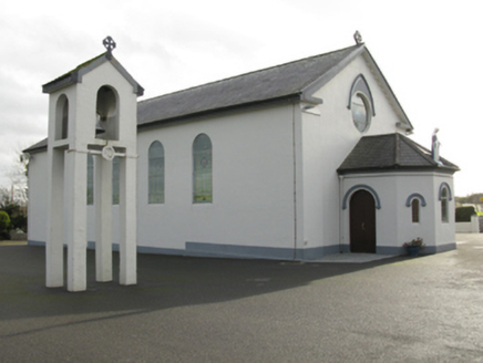 Catholic Church of Saint Mary and Saint MichaelChurch/chapel · 1.9 mi
Explorer Tom Catholic Church of Saint Mary and Saint Michael in Cloongawnagh refuses to fall down because it’s too proud of its Romanesque style. It’s got that arched look that makes it seem very serious indeed. Dare you to say hello to it out loud.
 Grave YardGraveyard · 3.1 mi
Explorer Tom Graveyard in Aghamore would post a photo of its mossy headstones with the caption 'Living my best quiet life, #ancient'. It’s got that moody, atmospheric vibe going on that makes you feel instantly profound. Have a wander and a wonder.
 CashelFairy fort / stone ringfort · 3.7 mi
Explorer Tom Another cashel in Kilcashel stands tall on the ridge, looking down its nose at everyone else with its thick, sturdy drystone walls. The builder was definitely thinking about views when they stacked those rocks, ignoring the wind and the cold completely. Bring biscuits, every good story needs biscuits.
 CastleCastle, unclassified · 5.2 mi
Explorer Tom Castle on Island Lake hates when people ask if it’s haunted; it prefers ‘mysteriously absent’. It vanished so fast the locals just shrugged and built a house instead. Bring a flask of something warm and a story to swap.
 IndicatedHouse, fortified house · 5.2 mi
Explorer Tom House in Island is currently being judged by rabbits who think its gunloops are just fancy holes for them to hide in. They’re not wrong, actually. Get there early and have it all to yourself.
 Knock ShrineHeritage attraction · 7.9 mi
Explorer Tom I'll keep my big mouth quiet for the people praying at Knock. Knock Shrine grew from an evening that the people present never forgot. On 21 August 1879, Mary Byrne and other villagers said they saw figures at the church gable while the Mayo rain came down. Their accounts describe a still scene that lasted nearly two hours, with people gathering and praying; the witnesses also said the ground around the figures stayed dry. I am not going to tell you what they saw. Mayo rain rarely asks my permission, but the witnesses' account asks for careful listening. What I can tell you is that their words were taken down by a church inquiry that autumn, and a second inquiry in 1936 returned to surviving witnesses because many early papers were thought lost. The original wall attracted so many visitors that pieces were taken away as souvenirs. Today this is a living place of pilgrimage, so enter with care for the people who have come to pray. Whatever you believe, listen to how a wet evening changed a village's place in the world.
 Curlew MountainsMountain / peak · 18 mi
Explorer Tom The Curlew Mountains may have nothing to do with curlew birds, which is awkward because I had prepared a terrific imitation. Their name likely grew from Irish words for rugged, pointed hills. Between Boyle and Castlebaldwin, hard sandstone and conglomerate rise above softer limestone country, giving this modest range its shape. The Battle of Curlew Pass took place here in 1599, a serious chapter that deserves a straight account. I would leave the bird call out of that story and use it only to annoy my travelling companion afterwards. Choose a lawful public trail or viewpoint, check local routes and weather, and treat any historic ground respectfully. Look at the ridgeline against the lower land. You can see why even these relatively low hills have long mattered.
 The Mórrígan: OweynagatLegend location · 19 mi
Explorer Tom The Mórrígan: Oweynagat is called the Cave of Cats, which fooled me into expecting a very ordinary sort of trouble. Then the tale sends the Mórrígan out of it during the Táin. If the cats saw her coming, I bet they made room.
 Caves of KeshCave · 19 mi
Explorer Tom Sixteen caves in one Sligo hillside? I would lose count halfway up and blame a ghost. The Caves of Kesh open across the west side of Keshcorran Hill, some chambers joining others inside pale limestone. Excavators found bones of brown bear, arctic lemming, Irish elk and wolf, an animal roll call that makes my own visitors look very tame. People also used the caves over many centuries, so the openings are part of a lived landscape as well as a geological one. I could make up a feast for every chamber, but the finds deserve better than my invented menu. The approach climbs steep ground and the caves are natural spaces, not a fitted visitor corridor; check access, weather and your footing. Carry a light if local guidance permits entry, and never push beyond your ability. From outside, the row of dark mouths already tells a fine story.
 Queen Medb: RathcroghanLegend location · 19 mi
Explorer Tom Queen Medb: Rathcroghan is where the Táin starts turning a quarrel about a bull into an epic. Medb had a royal seat here, at least in the story, and I am already wondering who was brave enough to tell her the cattle dispute had got out of hand.
 Kesh CorannMountain / peak · 19 mi
Explorer Tom Kesh Corann in County Sligo is basically the uncle at the wedding who won't stop talking about his harpist ancestor. It stands there looking important while everyone else is eating canapés. Have a sandwich here and call it a heritage lunch.
More historic places in County Mayo · All of County Mayo

What do you know about this place?Tap to add a comment or ask a question