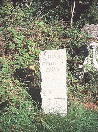
What is recorded here
Milestone or milepost in Kellyville still announces ‘Queen’s County 1763’. Other signs accept a change of address; this one has brought a lump of limestone to the argument and is prepared to wait.
Freestanding limestone monolithic county boundary stone, dated 1763, inscribed 'Queen's County 1763'.
From the Buildings of Ireland (National Inventory of Architectural Heritage) record 12801935
This does not grant access. Most recorded buildings are privately owned; view them only from public ground unless the owner allows entry.
Places near here
 Ballintubbert HouseRectory/glebe/vicarage/curate's house · 1350 yd
.jpg/250px-St_Brigid's_Well_(30653).jpg "Photo: A.-K. D., Wikimedia Commons · CC BY-SA 4.0") OutlinedHoly well · 1479 yd
OutlinedHoly well · 1479 yd.jpg/250px-St_Brigid's_Church_(61517).jpg "Photo: A.-K. D., Wikimedia Commons · CC BY-SA 4.0") Saint Brigid's Church (Ballyadams)Church/chapel · 1511 yd
Saint Brigid's Church (Ballyadams)Church/chapel · 1511 yd Dm PenderMemorial · 1512 yd
 Ballyadams CastleCastle · 1.6 mi
 Bawn in BallyadamsBawn · 1.6 mi
 Grave YardGraveyard · 1.8 mi
 Pedunculate Oak1.9 miPedunculate Oak2.0 mi
 Oughaval Wood MapVisitor information · 2.7 mi
 CemeteryGraveyard · 3.1 mi
 Town HallMuseum · 3.5 mi
Pictures: A.-K. D., Wikimedia Commons · CC BY-SA 4.0; Mike Searle, Geograph · CC BY-SA 2.0; Andrewmc, Wikimedia Commons · CC BY 4.0; Algirdas at Lithuanian Wikipedia, Wikimedia Commons · Public domain; Graham Horn, Geograph · CC BY-SA 2.0; Mgtmquinn, Wikimedia Commons · CC BY-SA 4.0
More historic places in County Laois · All of County Laois
What do you know about this place?