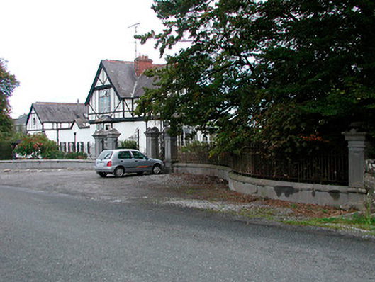
What is recorded here
Main entrance gates serving Middleton Park House (15318019), erected c.1850, comprising a central pair of moulded ashlar limestone gate piers (on square-plan having recessed panels to shaft and moulded ashlar limestone capstones over) supporting a pair of wrought-iron gates. Central gateway flanked to either side (north and south) by pedestrian entrances having ashlar limestone gate piers supporting wrought-iron gates. Pedestrian gates flanked by sections of ashlar limestone plinth walling having wrought-iron railings over and terminated by ashlar limestone gate piers. Located to the west of Middleton Park House and to the south of Castletown Geoghegan. Associated gate lodge (15318018) located adjacent to the northeast. Rubble limestone boundary wall runs away to the north and the south.
An impressive and well-detailed entrance gateway, which forms a suitably fine first impression when entering the grounds of Middleton Park House (15318019). This gateway is well-built using good quality ashlar limestone while the decorative wrought-iron gates and railings further embellish the aesthetics of this fine composition. The gate piers are constructed using the same gray ashlar limestone masonry used in construction of the main house, indicating that they were erected at the same time that Middleton Park House was rebuilt, c.1850 and providing architectural continuity between the two features. This gateway forms an interesting pair of related structures along with the attendant gate lodge (15318018) to the northwest and is an integral part of an extensive collection of structures associated with Middleton Park House. It represents an attractive feature, of some artistic merit, in the rural landscape to the south of Castletown Geoghegan.
This does not grant access. Most recorded buildings are privately owned; view them only from public ground unless the owner allows entry.
Places near here
 OutlinedEnclosure · 362 yd
 MotteRuins · 662 yd
 Castletown MoatCastle, motte and bailey · 688 yd
 BaileyRuins · 711 yd
 Partially hachuredFairy fort / earthen ringfort · 748 yd
 Site of CastleCastle, tower house · 833 yd
 Hill of UisneachMountain / peak · 4.8 mi
 Sam's ParkForest · 4.9 mi
 European ashEuropean ash · 5.2 mi
 Bonfire HillMountain / peak · 5.9 mi
 Kilmalady HillMountain / peak · 6.3 mi
 St. Columba's WellSpring · 7.8 mi
Other information
Photo: National Inventory of Architectural Heritage · Website use allowed for educational or private purposes with source credit