What is recorded here
From OpenStreetMap (© OpenStreetMap contributors) n4311163966
Places near here
Photo credits
- Kieran Evans, Wikimedia Commons · CC BY-SA 4.0
- Richard Webb, Geograph · CC BY-SA 2.0
- Patrice78500, Wikimedia Commons · CC BY-SA 3.0
- Shane Killen, Geograph · CC BY-SA 2.0
- National Inventory of Architectural Heritage
- John M, Geograph · CC BY-SA 2.0
- Andreas F. Borchert, Wikimedia Commons · CC BY-SA 4.0
- Rossographer, Geograph · CC BY-SA 2.0
- Kenneth Allen, Geograph · CC BY-SA 2.0
- Anne Burgess, Wikimedia Commons · CC BY-SA 2.0
 The Murder HoleCave · 1.3 mi
Explorer Tom The Murder Hole cave hints at darker history on its beach, though the name may simply be a local ghost story.
 Boyeeghter StrandBeach / strand · 1.4 mi
Explorer Tom Boyeeghter Strand bends into a horseshoe of sand near Melmore Head. That's a shape I can have fun with on the map: try drawing that curve in one sweep without lifting your pencil. The saved account warns of strong currents, so this is a map puzzle from me, not a swimming tip.
 Cnoc na SleáMountain / peak · 1.6 mi
Explorer Tom Cnoc na Sleá means 'hill of the spear', though I would leave any spear firmly in the name. The guide also calls this small Donegal hill Crocknasleigh and points out its older Irish spelling. One hill, two ways to say it, and a very pointed name.
 Trá na Rosann HostelHostel · 1.8 mi
Explorer Tom Trá na Rosann Hostel is pretending to be a castle to impress you. Honestly, it's just a bed with a view of the void. Check if anyone's hiding under your mattress before you sleep!
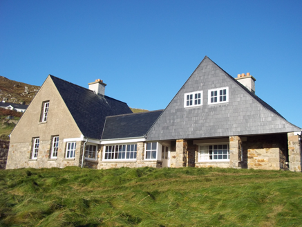 Tranarossan HouseHouse · 1.8 mi
Explorer Tom Tranarossan House was designed by the distinguished architect, Edwin Lutyens. I bet he looked at this modest little hilltop spot and thought, 'Right, let's use half my best ideas.' It feels like a giant wearing very small, cozy slippers.
 Rosses StrandBeach / strand · 2.1 mi
Explorer Tom Rosses Strand has a classic sound to it, promising gentle waves and wide spaces for exploration along the Donegal coast.
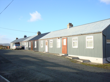 worker's house2.1 mi
Explorer Tom Worker's house in Tonbane Glebe is Ireland’s longest row of corrugated-metal houses. I picture the whole terrace stretching out like a giant, shiny accordion, waiting for someone to squeeze it and make a squeaky noise.
 Mevagh High CrossCross, High cross · 3.1 mi
Explorer Tom Mevagh High Cross is a stark, undecorated slab standing in the graveyard of a ruined medieval church. It’s simple and unadorned, which makes it feel like a quiet guardian overlooking the steep drop to Mulroy Bay. No fancy patterns here, just raw stone and history.
 Beach HotelHotel · 4.5 mi
Explorer Tom Beach Hotel in County Donegal is right by the beach, which means sand everywhere, including in places you didn't know existed. Pack a vacuum cleaner just to be safe.
 Moross CastleCastle, tower house · 4.9 mi
Explorer Tom Moross Castle was built in 1532 and sits on a tiny rocky island connected by a causeway. By 1622, someone had slapped a thatched roof on the ruins while it lay waste, which is peak medieval DIY. Only the southwest corner survives now, but that narrow causeway makes it feel like you’re walking onto a very defensive boat.
 Cliffs on Ros GuillPublicly named cliff or headland · 5.0 mi
Explorer Tom Ros Guill’s cliffs probably see their fair share of wind, so keep your hat on and watch where you step!
 Cliffs north of DowniesPublicly named cliff or headland · 5.0 mi
Explorer Tom The cliffs north of Downies likely hold secrets, so keep an eye out for private signs before you step too close.
More historic places in County Donegal · All of County Donegal

What do you know about this place?Tap to add a comment or ask a question