
What is recorded here
From OpenStreetMap (© OpenStreetMap contributors) n3810177332
Places near here
Picture notes
- Computer-made picture. It does not show this monument.
- Computer-made picture. It does not show this mountain top.
- Computer-made picture. It does not show this walking route.
- louise price, Geograph · Creative Commons Attribution-ShareAlike 2.0
- National Inventory of Architectural Heritage
- William Frederick Wakeman (1822-1900), Wikimedia Commons · Public domain
- Andreas F. Borchert, Wikimedia Commons · CC BY-SA 3.0 de
- Computer-made picture. It does not show this garden.
- D Gore, Geograph · CC BY-SA 2.0
 Standing stoneStanding stone, pair · 1072 ydComputer-made picture
Explorer Tom Standing stone is a pair on the almost inaccessible slopes of Croaghnameal mountain, marked as Carrickahattan on older maps. The surveyors couldn't even get close enough to inspect it properly, which makes me think it’s hiding from them. I bet it’s playing hide-and-seek with the wind and winning every time.
 CroaghnamealMountain / peak · 1151 ydComputer-made picture
Explorer Tom Croaghnameal has strong opinions about modern buildings, particularly that they are all just glorified cardboard boxes with bad lighting. It sighs loudly whenever a new housing estate goes up nearby. Stand still and listen; the wind tells it better than me.
 CroaghmeenMountain / peak · 1.2 miComputer-made picture
Explorer Tom Croaghmeen is locked in a bitter feud with the nearest tree, which refuses to grow taller just to spite it. It's the most dramatic hillside rivalry I've ever seen, and honestly, I'm taking the mountain's side. Whisper a secret at it; it keeps worse.
 Megalithic tomb in MeenacargaghMegalithic tomb · 2.3 miComputer-made picture
Explorer Tom Megalithic tomb in Meenacargagh involves a guy named Fagan claiming he saw pagan ruins back in 1846. He measured the stones, but a later field reviser was so unsure it even existed that they scribbled 'don't show on map' in his book. It’s a classic case of one man’s treasure being another man’s suspicious doodle.
 Leghowney Loop WalkOfficial walking route · 2.4 miComputer-made picture
Explorer Tom Leghowney Loop Walk is six point nine kilometres of moderate effort where you’ll pretend to enjoy the silence. It’s a loop, so you end up where you started, just slower. Look up, the best bit is always higher than you think, probably.
 Aghlem BridgeBridge · 2.6 mi
Explorer Tom Aghlem Bridge carries the road over the Drummenny River on one wide stone arch. The present bridge is dated to about 1860, but an 1837 map shows an earlier crossing here. I picture the old bridge nudging the new stonework: 'You think you're the first one on this spot?'
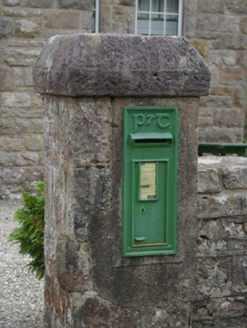 post box2.8 mi
Explorer Tom Post box in Copany is a cast-iron legend with Celtic Revival script. It’s got a P & T motif that looks like it was carved by a wizard. Give it a gentle pat and see if it rings out!
 Holy Well TrailWalking route · 3.5 miComputer-made picture
Explorer Tom Holy Well Trail has caught my eye in County Tyrone. I bet a walking route with a name like that could keep me talking all afternoon; I'm already inventing a daft little scene for it, and I'll stop before it turns into history.
 Saints IslandIsland · 3.9 mi
Explorer Tom Saints Island sounds like the place to land for the Lough Derg pilgrimage, but that is Station Island next door. This island held the early monastery; Lough Derg calls it overgrown and inaccessible. Even my map needs the two islands kept straight.
 Station IslandIsland · 4.6 mi
Explorer Tom Station Island is the Lough Derg pilgrimage island; the older monastery island is its neighbour, Saints Island. The traditional pilgrimage lasts three days. I would want the current dates and a proper booking sorted before I packed, because a lake crossing deserves more planning than my usual wandering.
 The CloisterGarden · 4.6 miComputer-made picture
Explorer Tom The Cloister in County Donegal is probably where monks went to complain about the canteen food. I bet they hid extra biscuits under the floorboards just to be spiteful. Count the crows, then count again and panic slightly.
 Harvey's PointRestaurant · 4.8 mi
Explorer Tom Harvey's Point is probably named after a guy who got lost and pointed in the wrong direction. Follow his lead; if you end up in a field of sheep, consider that an adventure.
More mountains and hills in County Donegal · All of County Donegal

What do you know about this place?Tap to add a comment or ask a question