
What is recorded here
From OpenStreetMap (© OpenStreetMap contributors) n332373182
Places near here
Photo credits
- Britishfinance, Wikimedia Commons · CC BY-SA 4.0
- Espresso Addict, Wikimedia Commons · CC BY-SA 2.0
- Nigel Thompson, Geograph · CC BY-SA 2.0
- Newbert12, Wikimedia Commons · CC BY-SA 4.0
- Maker not stated on source page, tr.pinterest.com
- Maker not stated on source page, www.pinterest.com
- National Inventory of Architectural Heritage
- Maker named on the Wikimedia Commons picture page · Public domain
- Didier Descouens, Wikimedia Commons · CC BY-SA 4.0
 An ChailleachMountain / peak · 1304 yd
Explorer Tom An Chailleach is in a massive feud with the rain; it hates getting wet, so it just stands there grumbling like a…
 MucanachtMountain / peak · 1.5 mi
Explorer Tom Mucanacht has been waiting since 1846 for a prophecy to come true, which was basically just a farmer promising to fix…
 Cnoc BreacMountain / peak · 1.9 mi
Explorer Tom Cnoc Breac is playing hide-and-seek between Benbrack and Knockbrack, hiding behind a deer fence like it's got somewhere…
 BenbrackMountain / peak · 2.0 mi
Explorer Tom Benbrack sits among Connemara's Twelve Bens looking as though somebody dropped a speckled stone into a gathering of…
 CrannogIslet · 2.7 mi
Explorer Tom Crannog has strict rules for visitors: no talking louder than a whisper, no touching the ancient wood, and absolutely…
 Ballynahinch Church (Moyrus)Church/chapel · 3.0 mi
Explorer Tom Ballynahinch Church (Moyrus) in Emlaghdauroe is sitting in a landscape that looks like it was made by a grumpy god. The…
 Megalithic tomb in LoughaunaMegalithic tomb · 3.4 mi
Explorer Tom Megalithic tomb in Loughauna is basically a pile of rocks that thinks it’s a fancy palace, which the rabbits find…
 Court tomb in CouravoughilCourt tomb · 3.7 mi
Explorer Tom Court tomb in Couravoughil is locked in a dramatic staring contest with the nearest tree, trying to decide who has…
 Standing stone in RosleagueStanding stone · 4.0 mi
Explorer Tom Standing stone in Rosleague is a squat boulder that handles nosy neighbours by just ignoring them from inside the…
 Traheen BridgeBridge · 4.0 mi
Explorer Tom Traheen Bridge in Attirowerty is all about that limestone flex, but honestly? I reckon the local dog has been running…
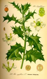 English holly5.0 mi
Explorer Tom English holly treats nosey neighbours with a spine, literally, because one wrong step and you’re crying on the grass.…
 Hawthorn5.0 mi
Explorer Tom The Hawthorn in County Galway has a secret talent for hiding acorns from squirrels that are actually just shiny…
More mountains and hills in County Galway · All of County Galway

What do you know about this place?Tap to add a comment or ask a question