
What is recorded here
From OpenStreetMap (© OpenStreetMap contributors) n8785522662
Places near here
Photo credits
- Ernest Riordan, Geograph · CC BY-SA 2.0
- Maker not stated on source page, www.tripadvisor.com
- Jonathan Thacker, Geograph · CC BY-SA 2.0
- Peter Ribbans, Wikimedia Commons · CC BY-SA 2.0
- National Inventory of Architectural Heritage
- Maker not stated on source page, www.pinterest.com
- Maker not stated on source page, www.gettyimages.no
- Nigel Cox https://www.geograph.org.uk/profile/2798, Wikimedia Commons · CC BY-SA 3.0
- Maker not stated on source page, www.infiniteireland.com
 KnocknagreeMountain / peak · 1758 yd
Explorer Tom Knocknagree is claimed to have been invented by a local man who just pointed at it one day. He says he named it…
 Standing stone in Ardgroom OutwardStanding stone · 2.1 mi
Explorer Tom Standing stone in Ardgroom Outward leans north like it’s dodging the wind. It’s basically a rectangular block…
 Eagle HillMountain / peak · 2.4 mi
Explorer Tom The other Eagle Hill exists because the map makers got confused and thought there were two eagles in the sky. It sits…
 Ballycrovane Ogham StoneVisitor attraction · 3.6 mi
Explorer Tom The Ballycrovane Ogham Stone claims King Arthur once leaned on it while complaining about his back, which nobody can…
 coastguard station3.7 mi
Explorer Tom “Coastguard station in Faunkill-and-the-woods had a fox take charge of the watch for a week and honestly did a better…
 garda station/constabulary barracks3.9 mi
Explorer Tom Garda station in Eyeries, County Cork is now a private house but still feels like you need to show an ID badge. Built…
 IllaunaraghteraIslet · 3.9 mi
Explorer Tom Illaunaraghtera in County Cork was once visited by a poet who fell into a ditch and called it artistic inspiration.…
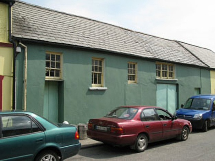 workshop4.0 mi
Explorer Tom Workshop in Eyeries has windows placed like it lost a bet with geometry. It’s still standing while others got…
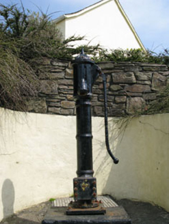 water pump4.0 mi
Explorer Tom Eyeries’ water pump is wearing a ram's head bucket grip like it’s a fancy accessory. Cast iron from 1870, and it’s…
 Stone sculptureStone sculpture, iconic · 4.2 mi
Explorer Tom Stone sculpture in Eyeries has a little human figure carved on the north face, looking a bit damaged. It’s in the…
 Hag of BearaMonument · 4.4 mi
Explorer Tom Hag of Beara in County Cork is stuck in a long-standing grudge with the weather, which keeps trying to blow her away.…
 Kilcatherine GraveyardGraveyard · 4.7 mi
Explorer Tom Kilcatherine Graveyard in County Cork is where a cow once tried to buy a plot with a carrot. It was rejected because…
More mountains and hills in County Cork · All of County Cork

What do you know about this place?Tap to add a comment or ask a question