What is recorded here
From OpenStreetMap (© OpenStreetMap contributors) w632428594
Places near here
Photo credits
- National Inventory of Architectural Heritage
- Meegan Builders, club building contractor; individual photographer not named, meeganbuilders.com
- Kieran Campbell, Geograph · CC BY-SA 2.0
- Maker not stated on source page, commons.wikimedia.org
- Maker not stated on source page, en.wikipedia.org
- David Crozier, Wikimedia Commons · CC BY-SA 2.0
- Eric Jones, Wikimedia Commons · CC BY-SA 2.0
- Maker not stated on source page, za.pinterest.com
- HENRY CLARK, Geograph · CC BY-SA 2.0
 Saint Michael's Community CentreChurch/chapel · 43 yd
Explorer Tom Saint Michael's Community Centre is secretly proud of a potato it grew in the garden last year. The timber roof…
 Donaghmoyne Post OfficeHouse · 107 yd
Explorer Tom Donaghmoyne Post Office is a prominent stone-built house in the village with a symmetrical facade and decorative…
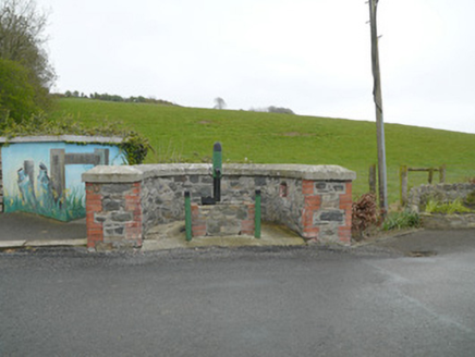 water pump124 yd
Explorer Tom Water pump in Cordrummans Middle would tell you after a few pints that the water tastes like regret and iron. Gaskin…
 Páirc Fontenoy, Donaghmoyne FontenoysGAA ground · 723 yd
 Mannan CastleArchaeological place · 784 yd
Explorer Tom Mannan Castle has the nerve to call itself a castle while looking, at first glance, like a very determined grassy hill.…
Mannan Castle (in ruins)Castle, Anglo-Norman masonry castle · 806 ydExplorer Tom Mannan Castle in Donaghmoyne would introduce itself as a very serious Anglo-Norman masonry castle that just happens to…
 Fairy fort / earthen ringfort in TonyellidaFairy fort / earthen ringfort · 945 yd
Explorer Tom Tonyellida's third fort is hiding a scandal right next to Blind Lough. It's D-shaped because it couldn't decide what…
 Court tomb in AnnahaiaCourt tomb · 1.0 mi
Explorer Tom Court tomb in Annahaia is officially destroyed, which means it’s basically a ghost story you can walk over without…
 Lough Ross Amenity AreaPark · 5.0 mi
Explorer Tom Lough Ross Amenity Area in County Armagh was where a priest once lost a bet about whether ducks could fly backwards…
 Battle of Newry RoadBattle · 6.4 mi
Explorer Tom Battle of Newry Road in County Armagh gave up chocolate for Lent because it was stressed about the whole military…
 Church & Graveyard: Killyoughran in UrcherChurch & Graveyard: Killyoughran · 6.4 mi
Explorer Tom Church & Graveyard: Killyoughran in Urcher would spend its lotto win on a new roof, probably. The 15th-century charm is…
 Medieval & post-med. church & graveyard in Creggan Bane GlebeMedieval & Post-med. Church & Graveyard · 6.7 mi
Explorer Tom Creggan Bane Glebe Church has been around since the medieval era and still hasn’t left. It probably has strict rules…
More memorials and graveyards in County Monaghan · All of County Monaghan

What do you know about this place?Tap to add a comment or ask a question