
What is recorded here
From OpenStreetMap (© OpenStreetMap contributors) n332372979
Places near here
Photo credits
- Maker not stated on source page, www.flickr.com
- Maker not stated on source page, en.wikipedia.org
- Graham Horn, Wikimedia Commons / Geograph Britain and Ireland
- National Inventory of Architectural Heritage
- Maker not stated on source page, au.pinterest.com
- Enjoy Irish Culture; photographer not stated, Enjoy Irish Culture
- Nmwood189, Wikimedia Commons · CC BY-SA 4.0
- Dr Wotsit, Wikimedia Commons · CC BY-SA 3.0
- Maker not stated on source page, www.pinterest.com
- Maker not stated on source page, br.pinterest.com
 Fairy fort / stone ringfort in An Mám ThiarFairy fort / stone ringfort · 1521 yd
Explorer Tom Fairy fort / stone ringfort in An Mám Thiar is perched up high, watching the valley like it owes them money. After a…
 Breenane GraveyardGraveyard · 1.3 mi
Explorer Tom Breenane Graveyard is where Vikings supposedly got lost looking for it because they couldn't read the map or the trees.…
 Western WayWalking route · 1.4 mi
Explorer Tom The Western Way sounds as if you just keep walking until somebody says you have reached the Atlantic. There is rather…
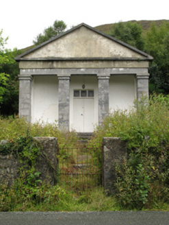 Maum CourthouseCourt house · 1.6 mi
Explorer Tom Maum Courthouse wants to resolve to stop judging everyone who walks past its temple front. It’s all dressed up in…
 Stone row in Cromghlinn Thoir,cromghlinn ThiarStone row · 1.7 mi
Explorer Tom Stone row in Cromghlinn Thoir and Thiar sounds like a line of people waiting for a bus that never comes. The name…
 Ric barracks1.8 mi
Explorer Tom RIC barracks in Teernakill North is derelict but still thinks it has authority, which is a bit much for a building. Its…
 Joyce Country SheepdogsHeritage attraction · 2.9 mi
Explorer Tom At Joyce Country Sheepdogs near Shanafaraghaun, a Border Collie can make a hillside full of Connemara Blackface sheep…
 CastlekirkCastle · 3.7 mi
Explorer Tom Castlekirk is called Hen's Castle, and no, I did not name it after my poultry empire. The ruin stands on a tiny…
 LackavreaMountain / peak · 3.8 mi
Explorer Tom Lackavrea rises between Lough Corrib and the Maamturks, a Galway summit that seems to have hired every bog in Connemara…
 CorcogemoreMountain / peak · 3.8 mi
Explorer Tom Corcogemore sits at the southern end of Galway’s Maamturk Mountains, looking as if someone set a great stone beehive…
 Heath IslandIslet · 5.2 mi
Explorer Tom Heath Island is where a love story went badly wrong because one partner got tangled in the heather and the other…
 Carrigeenfair IslandIslet · 5.2 mi
Explorer Tom Carrigeenfair Island is named after a fair but the map makers got it wrong because they thought ‘fair’ meant ‘pretty’…
More mountains and hills in County Galway · All of County Galway

What do you know about this place?Tap to add a comment or ask a question