
What is recorded here
Places near here
Photo credits
- National Inventory of Architectural Heritage
- N Chadwick, Geograph · Creative Commons Attribution-ShareAlike 2.0
- P L Chadwick, Geograph · CC BY-SA 2.0
- Golfing in Ireland; photographer not stated, Source publisher
- Maker not stated on source page, videohive.net
- Maker not stated on source page, uk.pinterest.com
- Maker not stated on source page, tr.pinterest.com
- Maker not stated on source page, au.pinterest.com
- Colin Park, Geograph · CC BY-SA 2.0
 Old Convent LodgeConvent/nunnery · 84 yd
Explorer Tom Old Convent Lodge in Mallaranny ended up in the wrong place by pure coincidence, or so it claims. Built in 1932, it’s…
 Catholic Church of the Immaculate ConceptionChurch/chapel · 117 yd
Explorer Tom Catholic Church of the Immaculate Conception in Mallaranny is dressed up in Irish Romanesque style, borrowing heavily…
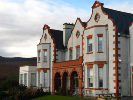 Mallaranny Railway HotelHotel · 378 yd
Explorer Tom Mallaranny Railway Hotel is perched on the edge of Trawoughter Strand, looking like it’s ready to welcome guests who…
 Mallaranny Railway StationStation master's house · 509 yd
Explorer Tom Mallaranny Railway Station Master’s House has a retirement plan involving becoming a very expensive shed for gardening…
 Mulranny Tourist OfficeVisitor information · 879 yd
Explorer Tom Mulranny Tourist Office sits on Main Street with solar panels that seem to be judging everyone who walks past without a…
 Mulranny Golf ClubGolf course · 1.0 mi
 Man-made underground passage in Inishkeel IslandMan-made underground passage · 3.5 mi
Explorer Tom Man-made underground passage in Inishkeel Island thinks the road leading to it is a bit of a joke. The entrance hole…
 Beetle Island SouthIslet · 3.8 mi
Explorer Tom Beetle Island South: I bet if this island reviewed its visitors, it would give them one star and say 'too much noise…
 Inishdeash moreIslet · 4.1 mi
Explorer Tom Inishdeash More in County Mayo would post a selfie with the caption 'living my best tiny life.' It’s probably jealous…
 Man-made underground passage in Beetle North IslandMan-made underground passage · 4.2 mi
Explorer Tom Man-made underground passage in Beetle North Island refuses to fall down because it knows it looks better standing than…
 Corranabinnia sw TopMountain / peak · 5.9 mi
Explorer Tom Corranabinnia sw Top has a strict plan for retirement, which involves doing absolutely nothing and letting the moss…
 CorranabinniaMountain / peak · 6.3 mi
Explorer Tom Corranabinnia rises out of Mayo's Nephin Begs like a mountain that has misplaced the road, the signposts and several…
More walking routes in County Mayo · All of County Mayo

What do you know about this place?Tap to add a comment or ask a question