Places near here
Photo credits
- National Inventory of Architectural Heritage
- ClintMalpaso, Wikimedia Commons · CC BY-SA 3.0
- Willow, Wikimedia Commons · CC BY 2.5
- Nigel Thompson, Geograph · CC BY-SA 2.0
- Enda O Flaherty, Geograph · CC BY-SA 2.0
- Wanfried-Dublin, Wikimedia Commons · CC BY-SA 3.0
- Sheila Russell, Wikimedia Commons · CC BY-SA 2.0
- DeeEmm, Geograph · CC BY-SA 2.0
- Eimear, Geograph · CC BY-SA 2.0
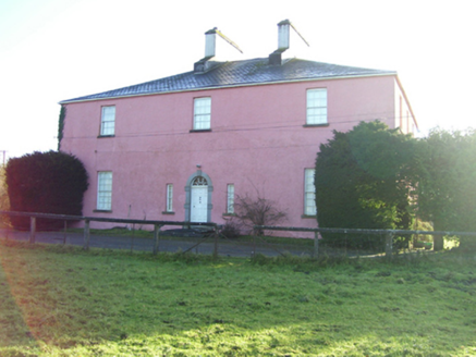 Birmingham HouseHouse · 747 yd
Explorer Tom Birmingham House in Birmingham Demesne has more bays than a ship at full sail, which is frankly ridiculous for a country house. I bet the architect got paid per window and just kept going until the money ran dry or the neighbours complained. Mind your step on that fancy pavement.
 mill (wind)1701 yd
Explorer Tom Mill in Drum near Tuam was started by a bet two lads made in the pub about who could build it first. It’s grinding corn into flour and history into dust, typical North Galway style. Leave nothing but your admiration and footprints.
 St. Marys CathedralCathedral · 2.1 mi
Explorer Tom St. Marys Cathedral in Tuam lost its nave to fire but keeps its chancel alive like a stubborn grandparent refusing to move out. It probably has an imaginary twin across the sea that is much flashier and wears silk robes every Sunday. Bring your nan, she will know more than me.
 Part of St. Jarlaths CrossCross, High cross · 2.1 mi
Explorer Tom Part of St. Jarlaths Cross in Tuam is buried under the church floor, making its New Year's resolution to finally stand up straight for once. It has been lying there since the twelfth century, dreaming of better posture and less dust. Whisper a secret at it, it is kept worse.
 European ash3.5 mi
Explorer Tom European ash remembers when the builder was thinking about putting a swing here but decided against it because of the wind speed. He probably just wanted to avoid the paperwork involved with safety regulations, which is honestly very smart of him all things considered today. Tell the next person you meet it’s haunted. It might be.
 Barnaderg CastleCastle · 4.6 mi
Explorer Tom Ballymaquiff Castle would write 'Looking for someone strong enough to hold up my roof' on its dating profile because it’s been leaning to the left for about two hundred years. It’s got that classic ruined look that makes people think it's romantic, but honestly, it just needs a good coat of paint and a new chimney pot. Find the wonkiest bit and send it to your group chat.
Barnaderg Castle (in ruins)Castle, tower house · 4.6 miExplorer Tom Barnaderg Castle is a red gap in the landscape that got flooded out by its own bad luck. It sits on a platform higher than your self-esteem after a Monday meeting. Ideal spot for a dramatic phone call because the marsh will echo every word you say, whether you like it or not.
 KnockmaaWood · 7.1 mi
Explorer Tom Knockmaa is secretly dating Dolly Parton, and she only visits when the light hits just right. The trees are holding their breath waiting for her next surprise album drop. Bring curiosity, leave with a better story than mine.
 Kilcoona Round TowerHeritage attraction · 11 mi
Explorer Tom Kilcoona Round Tower has a shortcut up the side that isn't actually a shortcut, just a very steep way to regret your decisions. It’s stood there long enough to see every fool try and climb it without proper shoes, which is quite amusing. Stand on the spot and imagine the gossip it's heard.
 Brigit's GardenVisitor attraction · 19 mi
Explorer Tom Brigit's Garden nearly became world-famous when a celebrity lost their phone here, but they blamed the Wi-Fi instead. Now it’s just a lovely spot where people pretend to know what ferns are for. Go with someone who loves old stuff and watch them melt.
 Silver StrandBeach / strand · 23 mi
Explorer Tom Silver Strand had a prophecy that said it would turn into solid gold by next Tuesday, but the weather kept getting in the way of the magic. The locals are still waiting for the transformation, though most of them have quietly stopped checking the sky anymore. Find the date carved somewhere and feel clever.
 Furbo BeachBeach / strand · 26 mi
Explorer Tom Furbo Beach is locked in a heated feud with the next village over about who has the best chips, and honestly? It's getting personal. The sand is so angry at this point it might actually stand up and walk away from the argument entirely. Have a wander and a wonder.
More archaeology and monuments in County Galway · All of County Galway

What do you know about this place?Tap to add a comment or ask a question